

Mátételke to Szt János utca 19., Bácsalmás
A cycling route starting in Bácsalmás, Bács-Kiskun county, Hungary.
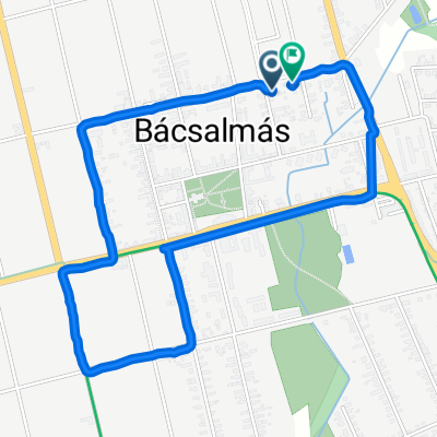
Overview
About this route
- 39 min
- Duration
- 9.4 km
- Distance
- 10 m
- Ascent
- 7 m
- Descent
- 14.4 km/h
- Avg. speed
- 121 m
- Max. altitude
Route quality
Waytypes & surfaces along the route
Waytypes
Access road
6.1 km
(65 %)
Track
0.8 km
(8 %)
Surfaces
Paved
1.7 km
(18 %)
Asphalt
1.7 km
(18 %)
Undefined
7.7 km
(82 %)
Continue with Bikemap
Use, edit, or download this cycling route
You would like to ride Mátételke to Szt János utca 19., Bácsalmás or customize it for your own trip? Here is what you can do with this Bikemap route:
Free features
- Save this route as favorite or in collections
- Copy & plan your own version of this route
- Sync your route with Garmin or Wahoo
Premium features
Free trial for 3 days, or one-time payment. More about Bikemap Premium.
- Navigate this route on iOS & Android
- Export a GPX / KML file of this route
- Create your custom printout (try it for free)
- Download this route for offline navigation
Discover more Premium features.
Get Bikemap PremiumFrom our community
Other popular routes starting in Bácsalmás
 2.nap_Bácsalmás-Villány (Magonyi Borszálló)
- Distance
- 104.6 km
- Ascent
- 86 m
- Descent
- 86 m
- Location
- Bácsalmás, Bács-Kiskun county, Hungary
 Zrínyi utca 33., Bácsalmás to Zrínyi utca 33., Bácsalmás
- Distance
- 31.1 km
- Ascent
- 125 m
- Descent
- 125 m
- Location
- Bácsalmás, Bács-Kiskun county, Hungary
 20p9 Bácsalmás-Szeged
- Distance
- 106.8 km
- Ascent
- 48 m
- Descent
- 93 m
- Location
- Bácsalmás, Bács-Kiskun county, Hungary
 Bácsalmás – Baja – Újpes
- Distance
- 209.3 km
- Ascent
- 67 m
- Descent
- 75 m
- Location
- Bácsalmás, Bács-Kiskun county, Hungary
 Buktisor - Kossuth Lajos utca
- Distance
- 1.1 km
- Ascent
- 0 m
- Descent
- 4 m
- Location
- Bácsalmás, Bács-Kiskun county, Hungary
 Mátételke to Szt János utca 19., Bácsalmás
- Distance
- 9.4 km
- Ascent
- 10 m
- Descent
- 7 m
- Location
- Bácsalmás, Bács-Kiskun county, Hungary
 5312 70, Bácsalmás - Dob utca 1, Bácsalmás
- Distance
- 2.3 km
- Ascent
- 7 m
- Descent
- 3 m
- Location
- Bácsalmás, Bács-Kiskun county, Hungary
 Rákóczi utca 11a., Bacsalmas to Rákóczi utca 9., Bacsalmas
- Distance
- 3.2 km
- Ascent
- 10 m
- Descent
- 10 m
- Location
- Bácsalmás, Bács-Kiskun county, Hungary
Open it in the app