
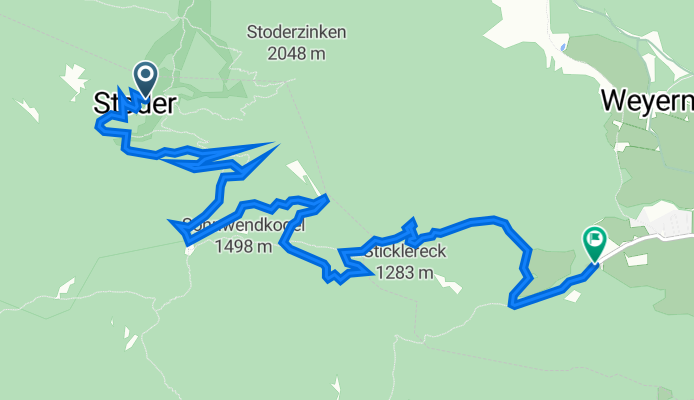
Stoder 2, Aich nach Dachstein-Tauern Panoramaweg 114, Gröbming
A cycling route starting in Gössenberg, Styria, Austria.
Overview
About this route
- 23 min
- Duration
- 9.6 km
- Distance
- 3 m
- Ascent
- 919 m
- Descent
- 25.5 km/h
- Avg. speed
- 1,836 m
- Max. altitude

Route quality
Waytypes & surfaces along the route
Waytypes
Road
9.2 km
(96 %)
Access road
0.4 km
(4 %)
Surfaces
Paved
9.2 km
(96 %)
Asphalt
9.2 km
(96 %)
Undefined
0.4 km
(4 %)
Continue with Bikemap
Use, edit, or download this cycling route
You would like to ride Stoder 2, Aich nach Dachstein-Tauern Panoramaweg 114, Gröbming or customize it for your own trip? Here is what you can do with this Bikemap route:
Free features
- Save this route as favorite or in collections
- Copy & plan your own version of this route
- Sync your route with Garmin or Wahoo
Premium features
Free trial for 3 days, or one-time payment. More about Bikemap Premium.
- Navigate this route on iOS & Android
- Export a GPX / KML file of this route
- Create your custom printout (try it for free)
- Download this route for offline navigation
Discover more Premium features.
Get Bikemap PremiumFrom our community
Other popular routes starting in Gössenberg
 Stoder 2, Aich nach Dachstein-Tauern Panoramaweg 114, Gröbming
- Distance
- 9.6 km
- Ascent
- 3 m
- Descent
- 919 m
- Location
- Gössenberg, Styria, Austria
 Kurztrum 55, Aich nach Mittergasse 206, Aich
- Distance
- 39.8 km
- Ascent
- 1,311 m
- Descent
- 1,298 m
- Location
- Gössenberg, Styria, Austria
 Gravel Bike - Aich Runde - Gravel Bike - Aich Runde
- Distance
- 32.1 km
- Ascent
- 1,071 m
- Descent
- 1,072 m
- Location
- Gössenberg, Styria, Austria
 Gemütliche Fahrt
- Distance
- 6.4 km
- Ascent
- 428 m
- Descent
- 416 m
- Location
- Gössenberg, Styria, Austria
 Aich - Gumpental - Krummholzhütte - Seewigtal - Aich
- Distance
- 57 km
- Ascent
- 1,617 m
- Descent
- 1,626 m
- Location
- Gössenberg, Styria, Austria
 Tauerntour2010 Teil2
- Distance
- 129.3 km
- Ascent
- 2,232 m
- Descent
- 2,207 m
- Location
- Gössenberg, Styria, Austria
 Schladming - 09Aich-Runde.gpx
- Distance
- 28.4 km
- Ascent
- 842 m
- Descent
- 842 m
- Location
- Gössenberg, Styria, Austria
 Aich Runde
- Distance
- 32.3 km
- Ascent
- 1,105 m
- Descent
- 1,104 m
- Location
- Gössenberg, Styria, Austria
Open it in the app