

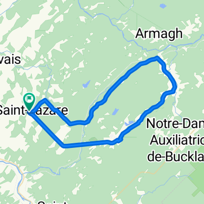
route pour aller chez Diane
A cycling route starting in Bellechasse Regional County Municipality, Quebec, Canada.
Overview
About this route
- -:--
- Duration
- 400.2 km
- Distance
- 1,811 m
- Ascent
- 1,811 m
- Descent
- ---
- Avg. speed
- 321 m
- Max. altitude

Route quality
Waytypes & surfaces along the route
Waytypes
Cycleway
108.1 km
(27 %)
Road
100.1 km
(25 %)
Surfaces
Paved
320.2 km
(80 %)
Unpaved
12 km
(3 %)
Asphalt
296.1 km
(74 %)
Paved (undefined)
24 km
(6 %)
Continue with Bikemap
Use, edit, or download this cycling route
You would like to ride route pour aller chez Diane or customize it for your own trip? Here is what you can do with this Bikemap route:
Free features
- Save this route as favorite or in collections
- Copy & plan your own version of this route
- Split it into stages to create a multi-day tour
- Sync your route with Garmin or Wahoo
Premium features
Free trial for 3 days, or one-time payment. More about Bikemap Premium.
- Navigate this route on iOS & Android
- Export a GPX / KML file of this route
- Create your custom printout (try it for free)
- Download this route for offline navigation
Discover more Premium features.
Get Bikemap PremiumFrom our community
Other popular routes starting in Bellechasse Regional County Municipality
 boucle piste cyclable Ste-Claire, St-Malachie, St-Lazare
- Distance
- 43.9 km
- Ascent
- 379 m
- Descent
- 378 m
- Location
- Bellechasse Regional County Municipality, Quebec, Canada
 route pour aller chez Diane
- Distance
- 400.2 km
- Ascent
- 1,811 m
- Descent
- 1,811 m
- Location
- Bellechasse Regional County Municipality, Quebec, Canada
 La presque pas de côtes du printemps
- Distance
- 39.9 km
- Ascent
- 696 m
- Descent
- 696 m
- Location
- Bellechasse Regional County Municipality, Quebec, Canada
 St-Lazare, St-Léon de Stanton, St-Damien, 65km, 1100m
- Distance
- 64.5 km
- Ascent
- 975 m
- Descent
- 975 m
- Location
- Bellechasse Regional County Municipality, Quebec, Canada
 maison 32km 220m
- Distance
- 32 km
- Ascent
- 265 m
- Descent
- 265 m
- Location
- Bellechasse Regional County Municipality, Quebec, Canada
 Saint-Lazare Bellechasse - boucle 52 km, 420 m
- Distance
- 52.1 km
- Ascent
- 396 m
- Descent
- 396 m
- Location
- Bellechasse Regional County Municipality, Quebec, Canada
 Cycloroute de Bellechasse
- Distance
- 83.4 km
- Ascent
- 29 m
- Descent
- 264 m
- Location
- Bellechasse Regional County Municipality, Quebec, Canada
 De la cycloroute de Bellechasse au Massif du sud
- Distance
- 28.3 km
- Ascent
- 574 m
- Descent
- 306 m
- Location
- Bellechasse Regional County Municipality, Quebec, Canada
Open it in the app