
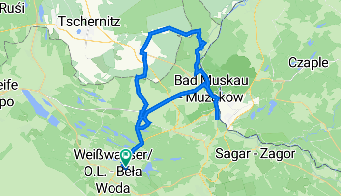
Brunnenstraße 4, Weißwasser/Oberlausitz nach Brunnenstraße 4, Weißwasser/Oberlausitz
A cycling route starting in Weißwasser, Saxony, Germany.
Overview
About this route
- 2 h 3 min
- Duration
- 30.9 km
- Distance
- 186 m
- Ascent
- 187 m
- Descent
- 15.1 km/h
- Avg. speed
- 159 m
- Avg. speed
Route quality
Waytypes & surfaces along the route
Waytypes
Quiet road
14.8 km
(48 %)
Busy road
5.1 km
(17 %)
Surfaces
Paved
19.2 km
(62 %)
Unpaved
0.2 km
(<1 %)
Asphalt
17.4 km
(56 %)
Paved (undefined)
1.4 km
(5 %)
Continue with Bikemap
Use, edit, or download this cycling route
You would like to ride Brunnenstraße 4, Weißwasser/Oberlausitz nach Brunnenstraße 4, Weißwasser/Oberlausitz or customize it for your own trip? Here is what you can do with this Bikemap route:
Free features
- Save this route as favorite or in collections
- Copy & plan your own version of this route
- Sync your route with Garmin or Wahoo
Premium features
Free trial for 3 days, or one-time payment. More about Bikemap Premium.
- Navigate this route on iOS & Android
- Export a GPX / KML file of this route
- Create your custom printout (try it for free)
- Download this route for offline navigation
Discover more Premium features.
Get Bikemap PremiumFrom our community
Other popular routes starting in Weißwasser
 Rf WSW BNärwalder See
- Distance
- 56.3 km
- Ascent
- 77 m
- Descent
- 79 m
- Location
- Weißwasser, Saxony, Germany
 Hermannstraße, Weißwasser/Oberlausitz nach Geschwister-Scholl-Straße, Krauschwitz
- Distance
- 7.5 km
- Ascent
- 65 m
- Descent
- 86 m
- Location
- Weißwasser, Saxony, Germany
 Himmelfahrt 2019
- Distance
- 44.8 km
- Ascent
- 71 m
- Descent
- 71 m
- Location
- Weißwasser, Saxony, Germany
 Schmiedestraße 1, Weißwasser/Oberlausitz do Schmiedestraße 1, Weißwasser/Oberlausitz
- Distance
- 72 km
- Ascent
- 237 m
- Descent
- 237 m
- Location
- Weißwasser, Saxony, Germany
 Auf den Spuren der Wölfe
- Distance
- 146.7 km
- Ascent
- 146 m
- Descent
- 206 m
- Location
- Weißwasser, Saxony, Germany
 Weißwasser - Mulkwitz
- Distance
- 15.9 km
- Ascent
- 56 m
- Descent
- 70 m
- Location
- Weißwasser, Saxony, Germany
 Planung 42,195 Tagebau
- Distance
- 41.9 km
- Ascent
- 111 m
- Descent
- 121 m
- Location
- Weißwasser, Saxony, Germany
 LK Görlitz - Rundfahrt
- Distance
- 279 km
- Ascent
- 1,481 m
- Descent
- 1,481 m
- Location
- Weißwasser, Saxony, Germany
Open it in the app