

Edersee-Radweg ER 20
A cycling route starting in Waldeck, Hesse, Germany.
Overview
About this route
www.ederseeradwege-4you.de with more info about the route and region (including topographic map of the route for printing, info about gastronomy, GPS data)
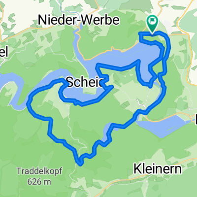
Sperrmauer - Rehbach - Bringhausen - Asel-South - Herzhausen - Kirchlotheim - Schmittlotheim - Altenlotheim- Frankenau - Gellershausen - Kleinern - Giflitz - Mehlen - Affoldern- Sperrmauer
Route length: 66 Km
Route description: The course leads around the national park: First, the route runs along the southern shore of the Edersee along the beautiful lakeside cycle path to Rehbach and Bringhausen. From Bringhausen to Asel-South, a equally beautiful lakeside path follows. In Asel-South we change shores, followed by a very beautiful, natural route to Herzhausen. From here, the path follows the Eder river upstream to Schmittlotheim. Along the Lorfe, you continue steadily uphill to Frankenau, gaining about 250 meters of elevation. Behind Frankenau, the maximum height is reached and the bike can now roll downhill to Gifflitz. A final uncomfortable climb from Hemfurth to the Sperrmauer rounds off the tour. Rest stops are marked on the map.
- -:--
- Duration
- 65.9 km
- Distance
- 974 m
- Ascent
- 982 m
- Descent
- ---
- Avg. speed
- 482 m
- Max. altitude

Route quality
Waytypes & surfaces along the route
Waytypes
Track
23.7 km
(36 %)
Path
16.5 km
(25 %)
Surfaces
Paved
36.9 km
(56 %)
Unpaved
23.1 km
(35 %)
Asphalt
34.9 km
(53 %)
Gravel
18.4 km
(28 %)
Route highlights
Points of interest along the route

Photo after 1.4 km

Photo after 1.5 km

Photo after 2.8 km

Point of interest after 4.5 km
Rehbachklause

Point of interest after 5.2 km
Strandoase

Point of interest after 5.4 km
Fischerhütte

Photo after 5.7 km

Photo after 6.5 km

Point of interest after 8.7 km
Campingplatz "Am Linge"

Point of interest after 10.1 km
Restaurant Endstation

Photo after 14.4 km

Point of interest after 16.9 km
Campingplatz Asel-Süd

Photo after 17.4 km
Asel-Fähre

Photo after 19.1 km

Photo after 23.2 km

Photo after 30.5 km

Photo after 34.9 km
Im Lorfetal

Point of interest after 43.3 km
Hofcafe Frebershausen

Photo after 51.4 km
Blick auf Kleinern

Photo after 53.3 km
Schönes Wesetal

Photo after 55.7 km

Photo after 65.7 km
Ederseesperrmauer

Point of interest after 65.9 km
Terrassenhotel (Loghouse)

Photo after 65.9 km
Monis Bootsverleih
Continue with Bikemap
Use, edit, or download this cycling route
You would like to ride Edersee-Radweg ER 20 or customize it for your own trip? Here is what you can do with this Bikemap route:
Free features
- Save this route as favorite or in collections
- Copy & plan your own version of this route
- Sync your route with Garmin or Wahoo
Premium features
Free trial for 3 days, or one-time payment. More about Bikemap Premium.
- Navigate this route on iOS & Android
- Export a GPX / KML file of this route
- Create your custom printout (try it for free)
- Download this route for offline navigation
Discover more Premium features.
Get Bikemap PremiumFrom our community
Other popular routes starting in Waldeck
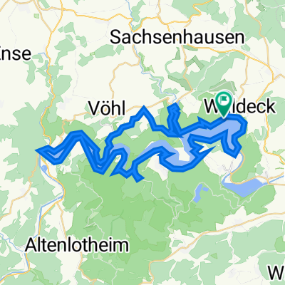
 Vom Edersee über Waldeck zum Ederbahnradweg
- Distance
- 14.6 km
- Ascent
- 244 m
- Descent
- 117 m
- Location
- Waldeck, Hesse, Germany
 Edersee-Radweg ER 77
- Distance
- 58.1 km
- Ascent
- 798 m
- Descent
- 797 m
- Location
- Waldeck, Hesse, Germany
 Ederseeradweg ER 35
- Distance
- 33.9 km
- Ascent
- 680 m
- Descent
- 678 m
- Location
- Waldeck, Hesse, Germany
 Ederseeradweg rundherum
- Distance
- 50.3 km
- Ascent
- 950 m
- Descent
- 949 m
- Location
- Waldeck, Hesse, Germany
 Ausfahrt durch Waldeck
- Distance
- 18.2 km
- Ascent
- 301 m
- Descent
- 303 m
- Location
- Waldeck, Hesse, Germany
 Ederseeradweg ER
- Distance
- 50.3 km
- Ascent
- 998 m
- Descent
- 994 m
- Location
- Waldeck, Hesse, Germany
 Kleine Sperrentour
- Distance
- 21.4 km
- Ascent
- 431 m
- Descent
- 431 m
- Location
- Waldeck, Hesse, Germany
 Edersee-Radweg ER 20
- Distance
- 65.9 km
- Ascent
- 974 m
- Descent
- 982 m
- Location
- Waldeck, Hesse, Germany
Open it in the app