
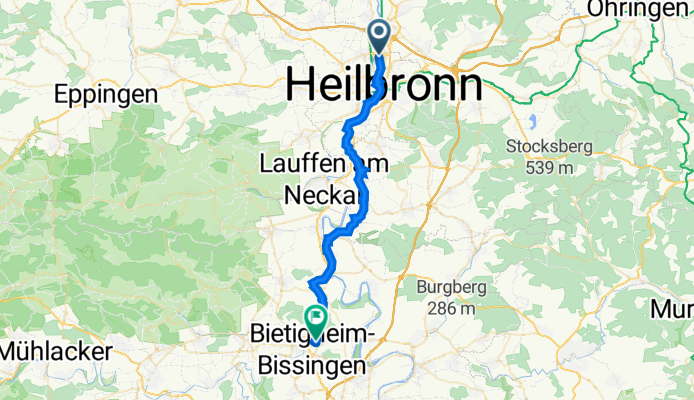
Salzgrundstraße 67, Heilbronn nach Großingersheimer Straße 80, Bietigheim-Bissingen
A cycling route starting in Neckarsulm, Baden-Württemberg, Germany.
Overview
About this route
- 1 h 38 min
- Duration
- 31.3 km
- Distance
- 244 m
- Ascent
- 190 m
- Descent
- 19.1 km/h
- Avg. speed
- 259 m
- Max. altitude
Route quality
Waytypes & surfaces along the route
Waytypes
Quiet road
8.1 km
(26 %)
Road
6 km
(19 %)
Surfaces
Paved
29.4 km
(94 %)
Unpaved
0.3 km
(1 %)
Asphalt
28.6 km
(91 %)
Paving stones
0.7 km
(2 %)
Continue with Bikemap
Use, edit, or download this cycling route
You would like to ride Salzgrundstraße 67, Heilbronn nach Großingersheimer Straße 80, Bietigheim-Bissingen or customize it for your own trip? Here is what you can do with this Bikemap route:
Free features
- Save this route as favorite or in collections
- Copy & plan your own version of this route
- Sync your route with Garmin or Wahoo
Premium features
Free trial for 3 days, or one-time payment. More about Bikemap Premium.
- Navigate this route on iOS & Android
- Export a GPX / KML file of this route
- Create your custom printout (try it for free)
- Download this route for offline navigation
Discover more Premium features.
Get Bikemap PremiumFrom our community
Other popular routes starting in Neckarsulm
 am Neckar runter und wieder rauf
- Distance
- 26.5 km
- Ascent
- 80 m
- Descent
- 79 m
- Location
- Neckarsulm, Baden-Württemberg, Germany
 Abendrunde
- Distance
- 26 km
- Ascent
- 164 m
- Descent
- 162 m
- Location
- Neckarsulm, Baden-Württemberg, Germany
 NSU-Pichterich - Steinerner Tisch (Variante zum Salzweg)
- Distance
- 15 km
- Ascent
- 302 m
- Descent
- 171 m
- Location
- Neckarsulm, Baden-Württemberg, Germany
 Aquatoll - Löwensteiner Berge - Brettachtal - Aquatoll
- Distance
- 63.7 km
- Ascent
- 507 m
- Descent
- 507 m
- Location
- Neckarsulm, Baden-Württemberg, Germany
 Breitenauersee
- Distance
- 50 km
- Ascent
- 1,654 m
- Descent
- 1,668 m
- Location
- Neckarsulm, Baden-Württemberg, Germany
 HN-Bad Wimpfen-Mosbach-Altstadt-Retoure
- Distance
- 66 km
- Ascent
- 224 m
- Descent
- 224 m
- Location
- Neckarsulm, Baden-Württemberg, Germany
 Heilbronn Neckar-Kocher-Jagst Rundstrecke
- Distance
- 50.9 km
- Ascent
- 203 m
- Descent
- 202 m
- Location
- Neckarsulm, Baden-Württemberg, Germany
 Mädelstour Pfingstmontag
- Distance
- 24 km
- Ascent
- 243 m
- Descent
- 243 m
- Location
- Neckarsulm, Baden-Württemberg, Germany
Open it in the app