

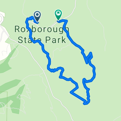
Waterton Road 11338, Littleton to Waterton Road 11338, Littleton
A cycling route starting in Roxborough Park, Colorado, United States.
Overview
About this route
- 1 h 42 min
- Duration
- 20.5 km
- Distance
- 127 m
- Ascent
- 100 m
- Descent
- 12.1 km/h
- Avg. speed
- 1,775 m
- Max. altitude

Route quality
Waytypes & surfaces along the route
Waytypes
Track
19.5 km
(95 %)
Cycleway
0.6 km
(3 %)
Surfaces
Paved
0.4 km
(2 %)
Unpaved
20.1 km
(98 %)
Unpaved (undefined)
18.9 km
(92 %)
Gravel
0.6 km
(3 %)
Continue with Bikemap
Use, edit, or download this cycling route
You would like to ride Waterton Road 11338, Littleton to Waterton Road 11338, Littleton or customize it for your own trip? Here is what you can do with this Bikemap route:
Free features
- Save this route as favorite or in collections
- Copy & plan your own version of this route
- Sync your route with Garmin or Wahoo
Premium features
Free trial for 3 days, or one-time payment. More about Bikemap Premium.
- Navigate this route on iOS & Android
- Export a GPX / KML file of this route
- Create your custom printout (try it for free)
- Download this route for offline navigation
Discover more Premium features.
Get Bikemap PremiumFrom our community
Other popular routes starting in Roxborough Park
 8500 W Deer Creek Canyon Rd, Littleton to 11811–12033 Waterton Rd, Littleton
- Distance
- 29.4 km
- Ascent
- 118 m
- Descent
- 125 m
- Location
- Roxborough Park, Colorado, United States
 Waterton Road 11338, Littleton to Waterton Road 11338, Littleton
- Distance
- 20.5 km
- Ascent
- 127 m
- Descent
- 100 m
- Location
- Roxborough Park, Colorado, United States
 8500 W Deer Creek Canyon Rd, Littleton to 8500 W Deer Creek Canyon Rd, Littleton
- Distance
- 20 km
- Ascent
- 96 m
- Descent
- 89 m
- Location
- Roxborough Park, Colorado, United States
 8500 W Deer Creek Canyon Rd, Littleton to 8500 W Deer Creek Canyon Rd, Littleton
- Distance
- 22.8 km
- Ascent
- 91 m
- Descent
- 92 m
- Location
- Roxborough Park, Colorado, United States
 Waterton Canyon, Littleton to Waterton Canyon, Littleton
- Distance
- 21.1 km
- Ascent
- 25 m
- Descent
- 29 m
- Location
- Roxborough Park, Colorado, United States
 Highline Canal Build
- Distance
- 75.4 km
- Ascent
- 277 m
- Descent
- 320 m
- Location
- Roxborough Park, Colorado, United States
 39.389, -105.274 to 39.389, -105.274
- Distance
- 25.8 km
- Ascent
- 526 m
- Descent
- 527 m
- Location
- Roxborough Park, Colorado, United States
 08.30.25
- Distance
- 4.9 km
- Ascent
- 169 m
- Descent
- 164 m
- Location
- Roxborough Park, Colorado, United States
Open it in the app