

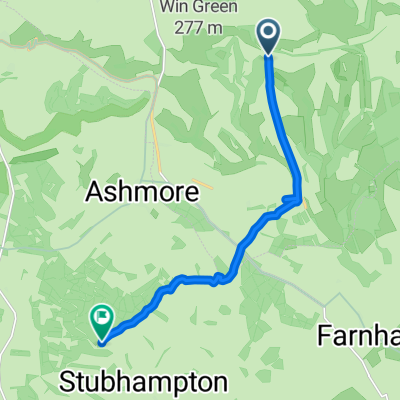
Recovered Route
A cycling route starting in Ansty, England, United Kingdom.
Overview
About this route
- 20 min
- Duration
- 1 km
- Distance
- 34 m
- Ascent
- 7 m
- Descent
- 3 km/h
- Avg. speed
- 136 m
- Max. altitude

Route quality
Waytypes & surfaces along the route
Waytypes
Pedestrian area
0.5 km
(52 %)
Quiet road
0.2 km
(22 %)
Surfaces
Unpaved
0.1 km
(9 %)
Gravel
0.1 km
(9 %)
Undefined
0.9 km
(91 %)
Continue with Bikemap
Use, edit, or download this cycling route
You would like to ride Recovered Route or customize it for your own trip? Here is what you can do with this Bikemap route:
Free features
- Save this route as favorite or in collections
- Copy & plan your own version of this route
- Sync your route with Garmin or Wahoo
Premium features
Free trial for 3 days, or one-time payment. More about Bikemap Premium.
- Navigate this route on iOS & Android
- Export a GPX / KML file of this route
- Create your custom printout (try it for free)
- Download this route for offline navigation
Discover more Premium features.
Get Bikemap PremiumFrom our community
Other popular routes starting in Ansty
 Cranbourne Chase Loop
- Distance
- 32.9 km
- Ascent
- 351 m
- Descent
- 351 m
- Location
- Ansty, England, United Kingdom
 pdc-1-v2
- Distance
- 51 km
- Ascent
- 397 m
- Descent
- 395 m
- Location
- Ansty, England, United Kingdom
 Rookery Lane, Swallowcliffe, Salisbury to 14 Western Road, Poole
- Distance
- 55.2 km
- Ascent
- 264 m
- Descent
- 350 m
- Location
- Ansty, England, United Kingdom
 day 4 - botony - hare on the hill
- Distance
- 83.7 km
- Ascent
- 626 m
- Descent
- 711 m
- Location
- Ansty, England, United Kingdom
 swing
swing- Distance
- 0.4 km
- Ascent
- 9 m
- Descent
- 3 m
- Location
- Ansty, England, United Kingdom
 berwick st john - hills loop
- Distance
- 31.2 km
- Ascent
- 529 m
- Descent
- 526 m
- Location
- Ansty, England, United Kingdom
 WWR-Tollard Royal Link
- Distance
- 9.2 km
- Ascent
- 109 m
- Descent
- 235 m
- Location
- Ansty, England, United Kingdom
 Upper North Road to Upper North Road
- Distance
- 17.4 km
- Ascent
- 257 m
- Descent
- 258 m
- Location
- Ansty, England, United Kingdom
Open it in the app