

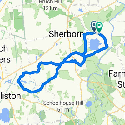
Whitney Street 43, Sherborn to Whitney Street 51, Sherborn
A cycling route starting in Sherborn, Massachusetts, United States.
Overview
About this route
- 3 min
- Duration
- 1.2 km
- Distance
- 0 m
- Ascent
- 0 m
- Descent
- 25.8 km/h
- Avg. speed
- 56 m
- Max. altitude

Route photos


Route quality
Waytypes & surfaces along the route
Waytypes
Cycleway
1.2 km
(99 %)
Quiet road
0 km
(1 %)
Surfaces
Paved
0 km
(2 %)
Unpaved
1.2 km
(97 %)
Gravel
1.2 km
(97 %)
Asphalt
0 km
(2 %)
Undefined
0 km
(1 %)
Continue with Bikemap
Use, edit, or download this cycling route
You would like to ride Whitney Street 43, Sherborn to Whitney Street 51, Sherborn or customize it for your own trip? Here is what you can do with this Bikemap route:
Free features
- Save this route as favorite or in collections
- Copy & plan your own version of this route
- Sync your route with Garmin or Wahoo
Premium features
Free trial for 3 days, or one-time payment. More about Bikemap Premium.
- Navigate this route on iOS & Android
- Export a GPX / KML file of this route
- Create your custom printout (try it for free)
- Download this route for offline navigation
Discover more Premium features.
Get Bikemap PremiumFrom our community
Other popular routes starting in Sherborn
 1–99 Morse Rd, Sherborn to Campus Dr, Natick
- Distance
- 21 km
- Ascent
- 293 m
- Descent
- 292 m
- Location
- Sherborn, Massachusetts, United States
 Whitney Street 43, Sherborn to Whitney Street 51, Sherborn
- Distance
- 1.2 km
- Ascent
- 0 m
- Descent
- 0 m
- Location
- Sherborn, Massachusetts, United States
 Route to Whitney Street 52, Sherborn
- Distance
- 34.1 km
- Ascent
- 63 m
- Descent
- 52 m
- Location
- Sherborn, Massachusetts, United States
 Dover loop
- Distance
- 18.1 km
- Ascent
- 180 m
- Descent
- 215 m
- Location
- Sherborn, Massachusetts, United States
 tk2......
- Distance
- 90.6 km
- Ascent
- 0 m
- Descent
- 0 m
- Location
- Sherborn, Massachusetts, United States
 Farm Rd, Sherborn to Farm Rd, Sherborn
- Distance
- 18.8 km
- Ascent
- 169 m
- Descent
- 170 m
- Location
- Sherborn, Massachusetts, United States
 Snail-like route in Needham
- Distance
- 13.7 km
- Ascent
- 140 m
- Descent
- 140 m
- Location
- Sherborn, Massachusetts, United States
 12mile loop
- Distance
- 19.9 km
- Ascent
- 129 m
- Descent
- 146 m
- Location
- Sherborn, Massachusetts, United States
Open it in the app