
Brejdak2023_600_2_2_DOJ
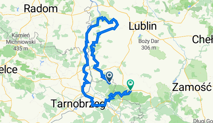
A cycling route starting in Zaklików, Subcarpathian Voivodeship, Poland.
Overview
About this route
- -:--
- Duration
- 335.5 km
- Distance
- 2,243 m
- Ascent
- 2,211 m
- Descent
- ---
- Avg. speed
- 278 m
- Max. altitude

Route quality
Waytypes & surfaces along the route
Waytypes
Quiet road
120.8 km
(36 %)
Track
93.9 km
(28 %)
Surfaces
Paved
161 km
(48 %)
Unpaved
80.5 km
(24 %)
Asphalt
151 km
(45 %)
Gravel
36.9 km
(11 %)
Continue with Bikemap
Use, edit, or download this cycling route
You would like to ride Brejdak2023_600_2_2_DOJ or customize it for your own trip? Here is what you can do with this Bikemap route:
Free features
- Save this route as favorite or in collections
- Copy & plan your own version of this route
- Split it into stages to create a multi-day tour
- Sync your route with Garmin or Wahoo
Premium features
Free trial for 3 days, or one-time payment. More about Bikemap Premium.
- Navigate this route on iOS & Android
- Export a GPX / KML file of this route
- Create your custom printout (try it for free)
- Download this route for offline navigation
Discover more Premium features.
Get Bikemap PremiumFrom our community
Other popular routes starting in Zaklików
![Zaklików - Sandomierz - Zaklików [23.07.2011]](https://media.bikemap.net/routes/1174711/staticmaps/in_992e7c95-4cd3-4740-8f53-81e098a37c41_400x400_bikemap-2021-3D-static.png) Zaklików - Sandomierz - Zaklików [23.07.2011]
Zaklików - Sandomierz - Zaklików [23.07.2011]- Distance
- 115.6 km
- Ascent
- 225 m
- Descent
- 223 m
- Location
- Zaklików, Subcarpathian Voivodeship, Poland
 Ujscie sanu
- Distance
- 100.4 km
- Ascent
- 101 m
- Descent
- 100 m
- Location
- Zaklików, Subcarpathian Voivodeship, Poland
 dookoła domu Jan.18.
- Distance
- 0.7 km
- Ascent
- 4 m
- Descent
- 14 m
- Location
- Zaklików, Subcarpathian Voivodeship, Poland
 Śladem Kolejki Waskotorowej
- Distance
- 20.1 km
- Ascent
- 93 m
- Descent
- 60 m
- Location
- Zaklików, Subcarpathian Voivodeship, Poland
 Skrzynki Zaklików - Rudnik
- Distance
- 104.8 km
- Ascent
- 196 m
- Descent
- 212 m
- Location
- Zaklików, Subcarpathian Voivodeship, Poland
 Śladem Kolejki Waskotorowej
- Distance
- 20.1 km
- Ascent
- 67 m
- Descent
- 41 m
- Location
- Zaklików, Subcarpathian Voivodeship, Poland
 dookoła domu
- Distance
- 0.7 km
- Ascent
- 3 m
- Descent
- 10 m
- Location
- Zaklików, Subcarpathian Voivodeship, Poland
 Gielnia, Zaklików do Gielnia, Zaklików
- Distance
- 13.8 km
- Ascent
- 102 m
- Descent
- 107 m
- Location
- Zaklików, Subcarpathian Voivodeship, Poland
Open it in the app