
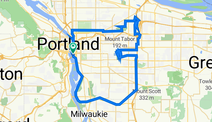
Springwater/Mt. Tabor/Rocky Butte loop
A cycling route starting in Portland, Oregon, United States.
Overview
About this route
- -:--
- Duration
- 49.4 km
- Distance
- 585 m
- Ascent
- 588 m
- Descent
- ---
- Avg. speed
- 205 m
- Max. altitude

Route quality
Waytypes & surfaces along the route
Waytypes
Path
16.5 km
(33 %)
Quiet road
13.2 km
(27 %)
Surfaces
Paved
30.7 km
(62 %)
Paved (undefined)
15 km
(30 %)
Asphalt
13.5 km
(27 %)
Continue with Bikemap
Use, edit, or download this cycling route
You would like to ride Springwater/Mt. Tabor/Rocky Butte loop or customize it for your own trip? Here is what you can do with this Bikemap route:
Free features
- Save this route as favorite or in collections
- Copy & plan your own version of this route
- Sync your route with Garmin or Wahoo
Premium features
Free trial for 3 days, or one-time payment. More about Bikemap Premium.
- Navigate this route on iOS & Android
- Export a GPX / KML file of this route
- Create your custom printout (try it for free)
- Download this route for offline navigation
Discover more Premium features.
Get Bikemap PremiumFrom our community
Other popular routes starting in Portland
 Springwater Corridor
- Distance
- 40.2 km
- Ascent
- 236 m
- Descent
- 162 m
- Location
- Portland, Oregon, United States
 Springwater/Mt. Tabor/Rocky Butte loop
- Distance
- 49.4 km
- Ascent
- 585 m
- Descent
- 588 m
- Location
- Portland, Oregon, United States
 8/21 ride4 fun
- Distance
- 19.6 km
- Ascent
- 85 m
- Descent
- 83 m
- Location
- Portland, Oregon, United States
 Large bridge loop
- Distance
- 17.3 km
- Ascent
- 110 m
- Descent
- 124 m
- Location
- Portland, Oregon, United States
 Loop from Home to Columbia River and Around River
- Distance
- 39.3 km
- Ascent
- 160 m
- Descent
- 194 m
- Location
- Portland, Oregon, United States
 Waterfront 8/9/17
- Distance
- 17 km
- Ascent
- 131 m
- Descent
- 133 m
- Location
- Portland, Oregon, United States
 Oswego Loop
- Distance
- 48.1 km
- Ascent
- 320 m
- Descent
- 325 m
- Location
- Portland, Oregon, United States
 Willamette Greenway, Portland to Willamette Greenway, Portland
- Distance
- 17.2 km
- Ascent
- 73 m
- Descent
- 74 m
- Location
- Portland, Oregon, United States
Open it in the app