

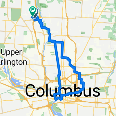
2109 Stella Ct, Columbus to 2109 Stella Ct, Columbus
A cycling route starting in Upper Arlington, Ohio, United States.
Overview
About this route
0
- 7 min
- Duration
- 1.7 km
- Distance
- 0 m
- Ascent
- 6 m
- Descent
- 13.5 km/h
- Avg. speed
- 230 m
- Max. altitude
Will Thornberry
created this 2 years ago
Route quality
Waytypes & surfaces along the route
Waytypes
Cycleway
1.3 km
80 %
Quiet road
0.2 km
11 %
Access road
0.2 km
10 %
Surfaces
Paved
1.5 km
(90 %)
Asphalt
1.5 km
90 %
Undefined
0.2 km
10 %
Continue with Bikemap
Use, edit, or download this cycling route
You would like to ride 2109 Stella Ct, Columbus to 2109 Stella Ct, Columbus or customize it for your own trip? Here is what you can do with this Bikemap route:
Free features
- Save this route as favorite or in collections
- Copy & plan your own version of this route
- Sync your route with Garmin or Wahoo
Premium features
Free trial for 3 days, or one-time payment. More about Bikemap Premium.
- Navigate this route on iOS & Android
- Export a GPX / KML file of this route
- Create your custom printout (try it for free)
- Download this route for offline navigation
Discover more Premium features.
Get Bikemap PremiumFrom our community
Other popular routes starting in Upper Arlington
- Quarry Valley Rd, Columbus to Quarry Valley Rd, Columbus0
- 0.8 km
- 6 m
- 6 m
- Upper Arlington, Ohio, United States
- Quarry Valley Rd, Columbus to Quarry Valley Rd, Columbus0
- 1.6 km
- 3 m
- 3 m
- Upper Arlington, Ohio, United States
- Lake Shore Dr, Columbus to Quarry Valley Rd, Columbus0
- 2.8 km
- 8 m
- 6 m
- Upper Arlington, Ohio, United States
- Quarry Valley Rd, Columbus to Quarry Valley Rd, Columbus0
- 0.8 km
- 0 m
- 0 m
- Upper Arlington, Ohio, United States
- Quarry Valley Rd, Columbus to Quarry Valley Rd, Columbus0
- 1.6 km
- 6 m
- 11 m
- Upper Arlington, Ohio, United States
- Riverside Dr, Columbus to Riverside Dr, Columbus0
- 10.3 km
- 44 m
- 45 m
- Upper Arlington, Ohio, United States


Open it in the app