Nachmittagsrunde 2
A cycling route starting in Ellrich, Free State of Thuringia, Germany.
Overview
About this route
Da die Strecke einige Steigungen aufweist, ist sie nur für gut trainierte Biker geeignet. Gerade jetzt im Herbst bietet sie aber eine beeindruckende Landschaft. Zwischen Wieda und Walkenried sollte der Radweg benutzt werden. In Walkenried füht der Weg unmittelbar am alten Zisterzienser-Kloster vorbei, das man zu den Öffnungszeiten besichtigen kann.
- -:--
- Duration
- 35.1 km
- Distance
- 273 m
- Ascent
- 273 m
- Descent
- ---
- Avg. speed
- ---
- Avg. speed
Continue with Bikemap
Use, edit, or download this cycling route
You would like to ride Nachmittagsrunde 2 or customize it for your own trip? Here is what you can do with this Bikemap route:
Free features
- Save this route as favorite or in collections
- Copy & plan your own version of this route
- Sync your route with Garmin or Wahoo
Premium features
Free trial for 3 days, or one-time payment. More about Bikemap Premium.
- Navigate this route on iOS & Android
- Export a GPX / KML file of this route
- Create your custom printout (try it for free)
- Download this route for offline navigation
Discover more Premium features.
Get Bikemap PremiumFrom our community
Other popular routes starting in Ellrich
- Ellrich - Hexentanzplatz
- Distance
- 6.3 km
- Ascent
- 115 m
- Descent
- 113 m
- Location
- Ellrich, Free State of Thuringia, Germany
- Grafschaftsrunde
- Distance
- 33 km
- Ascent
- 217 m
- Descent
- 214 m
- Location
- Ellrich, Free State of Thuringia, Germany
- Nachmittagsrunde 2
- Distance
- 35.1 km
- Ascent
- 273 m
- Descent
- 273 m
- Location
- Ellrich, Free State of Thuringia, Germany
- Trainingstour Sülzhayn-Hohe Strasse
- Distance
- 19.5 km
- Ascent
- 234 m
- Descent
- 230 m
- Location
- Ellrich, Free State of Thuringia, Germany
- Tour 25 Görsbach
- Distance
- 65.1 km
- Ascent
- 163 m
- Descent
- 163 m
- Location
- Ellrich, Free State of Thuringia, Germany
- NDH 003a: Große Südharzrunde vom Südharzhotel Sülzhayn
- Distance
- 49.3 km
- Ascent
- 711 m
- Descent
- 711 m
- Location
- Ellrich, Free State of Thuringia, Germany
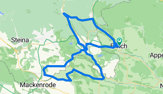
- Entspannende Route in
- Distance
- 24.8 km
- Ascent
- 450 m
- Descent
- 240 m
- Location
- Ellrich, Free State of Thuringia, Germany
- Ellrich - Rotesütte - Netzkater - Ilfeld...
- Distance
- 37 km
- Ascent
- 570 m
- Descent
- 561 m
- Location
- Ellrich, Free State of Thuringia, Germany
Open it in the app