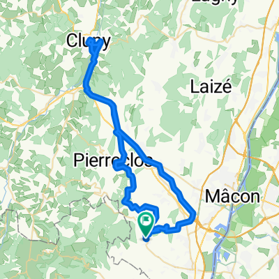
Route du Port d'Arciat, Crêches-sur-Saône nach Avenue Maréchal Foch 88, Saint-Genis-Laval
A cycling route starting in Crêches-sur-Saône, Bourgogne-Franche-Comté, France.
Overview
About this route
- 5 h 27 min
- Duration
- 78.8 km
- Distance
- 486 m
- Ascent
- 436 m
- Descent
- 14.5 km/h
- Avg. speed
- 269 m
- Max. altitude
Route quality
Waytypes & surfaces along the route
Waytypes
Busy road
22.1 km
(28 %)
Road
13.7 km
(17 %)
Surfaces
Paved
52 km
(66 %)
Unpaved
15.9 km
(20 %)
Asphalt
51.4 km
(65 %)
Gravel
15.2 km
(19 %)
Continue with Bikemap
Use, edit, or download this cycling route
You would like to ride Route du Port d'Arciat, Crêches-sur-Saône nach Avenue Maréchal Foch 88, Saint-Genis-Laval or customize it for your own trip? Here is what you can do with this Bikemap route:
Free features
- Save this route as favorite or in collections
- Copy & plan your own version of this route
- Sync your route with Garmin or Wahoo
Premium features
Free trial for 3 days, or one-time payment. More about Bikemap Premium.
- Navigate this route on iOS & Android
- Export a GPX / KML file of this route
- Create your custom printout (try it for free)
- Download this route for offline navigation
Discover more Premium features.
Get Bikemap PremiumFrom our community
Other popular routes starting in Crêches-sur-Saône
- Route du Port d'Arciat, Crêches-sur-Saône nach Avenue Maréchal Foch 88, Saint-Genis-Laval
- Distance
- 78.8 km
- Ascent
- 486 m
- Descent
- 436 m
- Location
- Crêches-sur-Saône, Bourgogne-Franche-Comté, France
- 62 km Leynes - Cluny
- Distance
- 62.3 km
- Ascent
- 738 m
- Descent
- 738 m
- Location
- Crêches-sur-Saône, Bourgogne-Franche-Comté, France
- 15 km Leynes - St. Amour - St. Vérand - Leynes
- Distance
- 15.1 km
- Ascent
- 328 m
- Descent
- 328 m
- Location
- Crêches-sur-Saône, Bourgogne-Franche-Comté, France
- 14. Tag Crêches-sur-Saône - Parcieux
- Distance
- 51.3 km
- Ascent
- 209 m
- Descent
- 213 m
- Location
- Crêches-sur-Saône, Bourgogne-Franche-Comté, France
- 2022 07 29 Charlon vio Cluny Frankreich
- Distance
- 79.1 km
- Ascent
- 572 m
- Descent
- 559 m
- Location
- Crêches-sur-Saône, Bourgogne-Franche-Comté, France
- Saint-Vérand - Cluny
- Distance
- 59.7 km
- Ascent
- 984 m
- Descent
- 972 m
- Location
- Crêches-sur-Saône, Bourgogne-Franche-Comté, France
- 63 km Leynes - Beaujeu - Leynes
- Distance
- 62.7 km
- Ascent
- 637 m
- Descent
- 637 m
- Location
- Crêches-sur-Saône, Bourgogne-Franche-Comté, France
- ETAPE 2
- Distance
- 85.8 km
- Ascent
- 493 m
- Descent
- 440 m
- Location
- Crêches-sur-Saône, Bourgogne-Franche-Comté, France
Open it in the app