

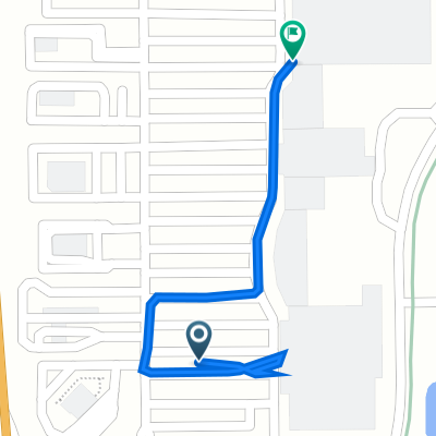
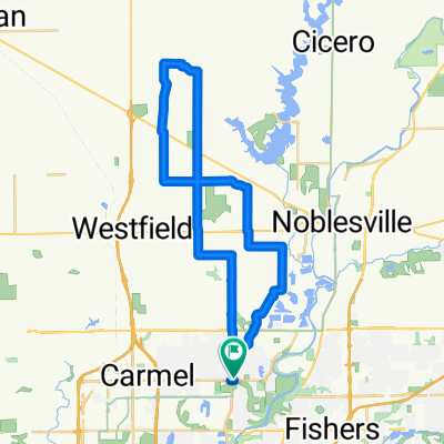
Recovered Route
A cycling route starting in Carmel, Indiana, United States.
Overview
About this route
- 1 h 4 min
- Duration
- 21.5 km
- Distance
- 115 m
- Ascent
- 125 m
- Descent
- 20 km/h
- Avg. speed
- 264 m
- Max. altitude
Route quality
Waytypes & surfaces along the route
Waytypes
Cycleway
15.9 km
(74 %)
Road
2.8 km
(13 %)
Surfaces
Paved
20.6 km
(96 %)
Asphalt
19.5 km
(91 %)
Concrete
1.1 km
(5 %)
Undefined
0.9 km
(4 %)
Continue with Bikemap
Use, edit, or download this cycling route
You would like to ride Recovered Route or customize it for your own trip? Here is what you can do with this Bikemap route:
Free features
- Save this route as favorite or in collections
- Copy & plan your own version of this route
- Sync your route with Garmin or Wahoo
Premium features
Free trial for 3 days, or one-time payment. More about Bikemap Premium.
- Navigate this route on iOS & Android
- Export a GPX / KML file of this route
- Create your custom printout (try it for free)
- Download this route for offline navigation
Discover more Premium features.
Get Bikemap PremiumFrom our community
Other popular routes starting in Carmel
 Gravel 31m
- Distance
- 51.1 km
- Ascent
- 75 m
- Descent
- 75 m
- Location
- Carmel, Indiana, United States
 1960 E Greyhound Pass, Westfield to 2001 E 151st St, Westfield
- Distance
- 0.5 km
- Ascent
- 0 m
- Descent
- 0 m
- Location
- Carmel, Indiana, United States
 Around Carmel
- Distance
- 23.5 km
- Ascent
- 40 m
- Descent
- 41 m
- Location
- Carmel, Indiana, United States
 local circuit
- Distance
- 18.5 km
- Ascent
- 29 m
- Descent
- 30 m
- Location
- Carmel, Indiana, United States
 12801–12851 Grand Blvd, Carmel to 12840 Old Meridian St, Carmel
- Distance
- 10.5 km
- Ascent
- 20 m
- Descent
- 21 m
- Location
- Carmel, Indiana, United States
 12800–12880 Grand Blvd, Carmel to 12780 Old Meridian St, Carmel
- Distance
- 10.3 km
- Ascent
- 24 m
- Descent
- 25 m
- Location
- Carmel, Indiana, United States
 Northview Ride
- Distance
- 41.3 km
- Ascent
- 59 m
- Descent
- 64 m
- Location
- Carmel, Indiana, United States
 2003 E Greyhound Pass, Westfield to 2222 E 146th St, Westfield
- Distance
- 0.5 km
- Ascent
- 0 m
- Descent
- 13 m
- Location
- Carmel, Indiana, United States
Open it in the app