

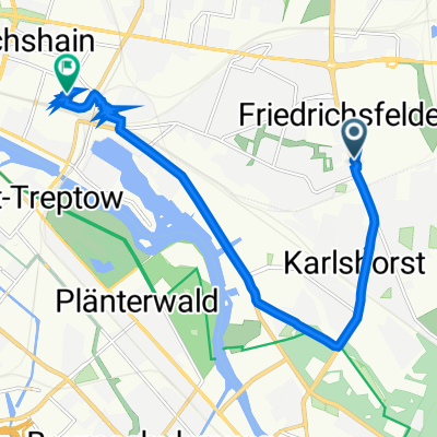
Mellenseestraße 57, Berlin nach Straße ohne Straßennamen, Berlin
A cycling route starting in Friedrichsfelde, State of Berlin, Germany.
Overview
About this route
- 33 min
- Duration
- 9.8 km
- Distance
- 6 m
- Ascent
- 39 m
- Descent
- 17.7 km/h
- Avg. speed
- 76 m
- Max. altitude

Route quality
Waytypes & surfaces along the route
Waytypes
Pedestrian area
2.6 km
(27 %)
Road
2.4 km
(25 %)
Surfaces
Paved
8.2 km
(84 %)
Unpaved
0.5 km
(5 %)
Asphalt
7.1 km
(73 %)
Concrete
1.1 km
(11 %)
Continue with Bikemap
Use, edit, or download this cycling route
You would like to ride Mellenseestraße 57, Berlin nach Straße ohne Straßennamen, Berlin or customize it for your own trip? Here is what you can do with this Bikemap route:
Free features
- Save this route as favorite or in collections
- Copy & plan your own version of this route
- Sync your route with Garmin or Wahoo
Premium features
Free trial for 3 days, or one-time payment. More about Bikemap Premium.
- Navigate this route on iOS & Android
- Export a GPX / KML file of this route
- Create your custom printout (try it for free)
- Download this route for offline navigation
Discover more Premium features.
Get Bikemap PremiumFrom our community
Other popular routes starting in Friedrichsfelde
 Rennradgruppentour durchs Oderbruch
- Distance
- 184.6 km
- Ascent
- 376 m
- Descent
- 377 m
- Location
- Friedrichsfelde, State of Berlin, Germany
 Lieblingsrunde 1
- Distance
- 111 km
- Ascent
- 187 m
- Descent
- 187 m
- Location
- Friedrichsfelde, State of Berlin, Germany
 kleine Runde am Morgen
- Distance
- 27.7 km
- Ascent
- 63 m
- Descent
- 43 m
- Location
- Friedrichsfelde, State of Berlin, Germany
 Sewanstrasse - Fürstenwalde a zpět
- Distance
- 97.3 km
- Ascent
- 80 m
- Descent
- 81 m
- Location
- Friedrichsfelde, State of Berlin, Germany
 Arbeit
- Distance
- 17.2 km
- Ascent
- 49 m
- Descent
- 44 m
- Location
- Friedrichsfelde, State of Berlin, Germany
 Bezirk Lichtenberg, Berlin nach Simplonstraße 55, Berlin
- Distance
- 10 km
- Ascent
- 62 m
- Descent
- 96 m
- Location
- Friedrichsfelde, State of Berlin, Germany
 Lichtenberg --> Prieros
- Distance
- 46.5 km
- Ascent
- 77 m
- Descent
- 82 m
- Location
- Friedrichsfelde, State of Berlin, Germany
 Berliner Umland 1
- Distance
- 99.5 km
- Ascent
- 222 m
- Descent
- 217 m
- Location
- Friedrichsfelde, State of Berlin, Germany
Open it in the app