
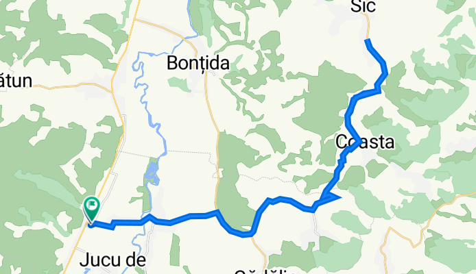
Juc - Sic
A cycling route starting in Apahida, Cluj County, Romania.
Overview
About this route
- -:--
- Duration
- 38.3 km
- Distance
- 309 m
- Ascent
- 309 m
- Descent
- ---
- Avg. speed
- 373 m
- Max. altitude

Route quality
Waytypes & surfaces along the route
Waytypes
Road
6.1 km
(16 %)
Quiet road
2.7 km
(7 %)
Undefined
29.5 km
(77 %)
Surfaces
Paved
35.7 km
(93 %)
Unpaved
0.4 km
(1 %)
Asphalt
35.7 km
(93 %)
Gravel
0.4 km
(1 %)
Undefined
2.3 km
(6 %)
Continue with Bikemap
Use, edit, or download this cycling route
You would like to ride Juc - Sic or customize it for your own trip? Here is what you can do with this Bikemap route:
Free features
- Save this route as favorite or in collections
- Copy & plan your own version of this route
- Sync your route with Garmin or Wahoo
Premium features
Free trial for 3 days, or one-time payment. More about Bikemap Premium.
- Navigate this route on iOS & Android
- Export a GPX / KML file of this route
- Create your custom printout (try it for free)
- Download this route for offline navigation
Discover more Premium features.
Get Bikemap PremiumFrom our community
Other popular routes starting in Apahida
 ride from (null) to Cluj-Napoca
- Distance
- 18.2 km
- Ascent
- 322 m
- Descent
- 296 m
- Location
- Apahida, Cluj County, Romania
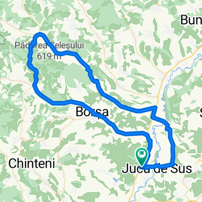 Jucu - Borsa - Panticeu - Dabaca - Bontida - Jucu
- Distance
- 77.5 km
- Ascent
- 318 m
- Descent
- 321 m
- Location
- Apahida, Cluj County, Romania
 Apahida-Caianu Vama-Tauseni-Bontida-Apahida
- Distance
- 47.4 km
- Ascent
- 558 m
- Descent
- 560 m
- Location
- Apahida, Cluj County, Romania
 Campenesti - Cluj Napoca - Campenesti
- Distance
- 30.1 km
- Ascent
- 417 m
- Descent
- 417 m
- Location
- Apahida, Cluj County, Romania
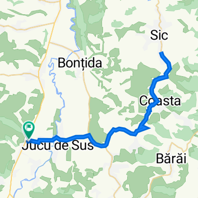 Juc - Sic
- Distance
- 38.3 km
- Ascent
- 309 m
- Descent
- 309 m
- Location
- Apahida, Cluj County, Romania
 Apahida - Bontida - Sic - Apahida pe sate
- Distance
- 52.5 km
- Ascent
- 609 m
- Descent
- 597 m
- Location
- Apahida, Cluj County, Romania
 Apahida-Dezmir-Boju-Cojocna-Apahida
- Distance
- 40.5 km
- Ascent
- 502 m
- Descent
- 503 m
- Location
- Apahida, Cluj County, Romania
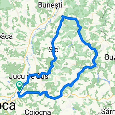 Apahida-Taga-Gherla-Sic-Apahida
- Distance
- 98 km
- Ascent
- 487 m
- Descent
- 488 m
- Location
- Apahida, Cluj County, Romania
Open it in the app