

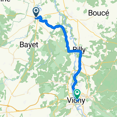
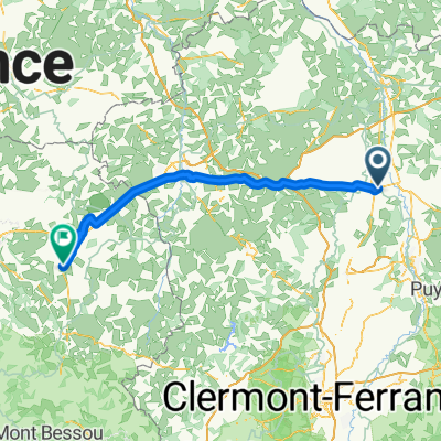
23_Transfer1
A cycling route starting in Saint-Pourçain-sur-Sioule, Auvergne-Rhône-Alpes, France.
Overview
About this route
- -:--
- Duration
- 80.1 km
- Distance
- 1,208 m
- Ascent
- 693 m
- Descent
- ---
- Avg. speed
- 887 m
- Max. altitude

Route quality
Waytypes & surfaces along the route
Waytypes
Road
50.5 km
(63 %)
Quiet road
20 km
(25 %)
Surfaces
Paved
24.8 km
(31 %)
Asphalt
20.8 km
(26 %)
Paved (undefined)
4 km
(5 %)
Undefined
55.3 km
(69 %)
Continue with Bikemap
Use, edit, or download this cycling route
You would like to ride 23_Transfer1 or customize it for your own trip? Here is what you can do with this Bikemap route:
Free features
- Save this route as favorite or in collections
- Copy & plan your own version of this route
- Split it into stages to create a multi-day tour
- Sync your route with Garmin or Wahoo
Premium features
Free trial for 3 days, or one-time payment. More about Bikemap Premium.
- Navigate this route on iOS & Android
- Export a GPX / KML file of this route
- Create your custom printout (try it for free)
- Download this route for offline navigation
Discover more Premium features.
Get Bikemap PremiumFrom our community
Other popular routes starting in Saint-Pourçain-sur-Sioule
 20181005_Saint Pourcain-sur-S-Vichy
- Distance
- 32.7 km
- Ascent
- 198 m
- Descent
- 167 m
- Location
- Saint-Pourçain-sur-Sioule, Auvergne-Rhône-Alpes, France
 23_TYF1
- Distance
- 88.5 km
- Ascent
- 949 m
- Descent
- 949 m
- Location
- Saint-Pourçain-sur-Sioule, Auvergne-Rhône-Alpes, France
 Tour 11 Vichy - Chenerailles
- Distance
- 106.3 km
- Ascent
- 889 m
- Descent
- 621 m
- Location
- Saint-Pourçain-sur-Sioule, Auvergne-Rhône-Alpes, France
 1984_Frankreich_T13_Saint-Pourcain-sur-Sioule_Miremont
- Distance
- 90.5 km
- Ascent
- 869 m
- Descent
- 592 m
- Location
- Saint-Pourçain-sur-Sioule, Auvergne-Rhône-Alpes, France
 Boucle Bocage Bourbonnais
- Distance
- 174.3 km
- Ascent
- 915 m
- Descent
- 903 m
- Location
- Saint-Pourçain-sur-Sioule, Auvergne-Rhône-Alpes, France
 14. Saint Pourçain sur Sioul - Lyon
- Distance
- 196.3 km
- Ascent
- 1,395 m
- Descent
- 1,478 m
- Location
- Saint-Pourçain-sur-Sioule, Auvergne-Rhône-Alpes, France
 Boucle Montagne Bourbonnaise
- Distance
- 177.5 km
- Ascent
- 1,246 m
- Descent
- 1,246 m
- Location
- Saint-Pourçain-sur-Sioule, Auvergne-Rhône-Alpes, France
 11_F/Saint-Pourçain-sur-Sioule-Guéret
- Distance
- 131.7 km
- Ascent
- 1,461 m
- Descent
- 1,306 m
- Location
- Saint-Pourçain-sur-Sioule, Auvergne-Rhône-Alpes, France
Open it in the app