
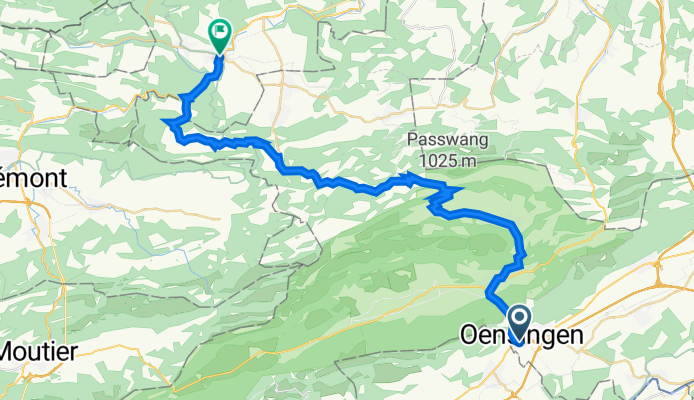
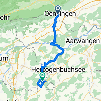
Oensingen nach Laufen
A cycling route starting in Oensingen, Canton of Solothurn, Switzerland.
Overview
About this route
- 2 h 15 min
- Duration
- 39.8 km
- Distance
- 1,230 m
- Ascent
- 1,337 m
- Descent
- 17.7 km/h
- Avg. speed
- 990 m
- Max. altitude

Route quality
Waytypes & surfaces along the route
Waytypes
Road
5.6 km
(14 %)
Quiet road
4.8 km
(12 %)
Surfaces
Paved
38.6 km
(97 %)
Unpaved
0.4 km
(1 %)
Asphalt
38.6 km
(97 %)
Gravel
0.4 km
(1 %)
Undefined
0.8 km
(2 %)
Continue with Bikemap
Use, edit, or download this cycling route
You would like to ride Oensingen nach Laufen or customize it for your own trip? Here is what you can do with this Bikemap route:
Free features
- Save this route as favorite or in collections
- Copy & plan your own version of this route
- Sync your route with Garmin or Wahoo
Premium features
Free trial for 3 days, or one-time payment. More about Bikemap Premium.
- Navigate this route on iOS & Android
- Export a GPX / KML file of this route
- Create your custom printout (try it for free)
- Download this route for offline navigation
Discover more Premium features.
Get Bikemap PremiumFrom our community
Other popular routes starting in Oensingen
 Oensingen nach Laufen
- Distance
- 39.8 km
- Ascent
- 1,230 m
- Descent
- 1,337 m
- Location
- Oensingen, Canton of Solothurn, Switzerland
 Erlinsburgweg 4, Oensingen nach Seeberg
- Distance
- 22.3 km
- Ascent
- 146 m
- Descent
- 167 m
- Location
- Oensingen, Canton of Solothurn, Switzerland
 Gigathlon 2012
- Distance
- 103.7 km
- Ascent
- 1,597 m
- Descent
- 1,661 m
- Location
- Oensingen, Canton of Solothurn, Switzerland
 Oensingen Allerheiligenberg
- Distance
- 37.6 km
- Ascent
- 817 m
- Descent
- 814 m
- Location
- Oensingen, Canton of Solothurn, Switzerland
 Gigathlon 2012 - Rennvelostrecke Samstag
- Distance
- 101.4 km
- Ascent
- 1,501 m
- Descent
- 1,588 m
- Location
- Oensingen, Canton of Solothurn, Switzerland
 Sur la Scheulte
- Distance
- 45 km
- Ascent
- 1,675 m
- Descent
- 845 m
- Location
- Oensingen, Canton of Solothurn, Switzerland
 Erlinsburgweg 4, Oensingen nach Burgäschi
- Distance
- 21.8 km
- Ascent
- 187 m
- Descent
- 203 m
- Location
- Oensingen, Canton of Solothurn, Switzerland
 Aegertenweg, Oensingen nach Aegertenweg, Oensingen
- Distance
- 17.5 km
- Ascent
- 581 m
- Descent
- 579 m
- Location
- Oensingen, Canton of Solothurn, Switzerland
Open it in the app