

PICO BELLOTA
A cycling route starting in Navajas, Valencia, Spain.
Overview
About this route
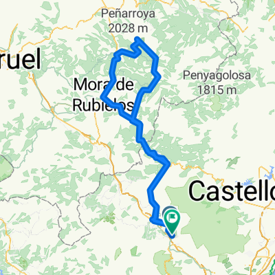
CLIMB TO PICO BELLOTA, SPECTACULAR. THIS ROUTE IS PARTLY ON THE ROAD BECAUSE IT WAS GETTING LATE.
- -:--
- Duration
- 64.9 km
- Distance
- 875 m
- Ascent
- 870 m
- Descent
- ---
- Avg. speed
- ---
- Max. altitude

Continue with Bikemap
Use, edit, or download this cycling route
You would like to ride PICO BELLOTA or customize it for your own trip? Here is what you can do with this Bikemap route:
Free features
- Save this route as favorite or in collections
- Copy & plan your own version of this route
- Sync your route with Garmin or Wahoo
Premium features
Free trial for 3 days, or one-time payment. More about Bikemap Premium.
- Navigate this route on iOS & Android
- Export a GPX / KML file of this route
- Create your custom printout (try it for free)
- Download this route for offline navigation
Discover more Premium features.
Get Bikemap PremiumFrom our community
Other popular routes starting in Navajas
 Navajas-Olba-Pistas de esqui
- Distance
- 204.6 km
- Ascent
- 2,668 m
- Descent
- 2,636 m
- Location
- Navajas, Valencia, Spain
 BTT Alto Palancia - Vega del Palancia
- Distance
- 27.4 km
- Ascent
- 250 m
- Descent
- 252 m
- Location
- Navajas, Valencia, Spain
 PICO BELLOTA
- Distance
- 64.9 km
- Ascent
- 875 m
- Descent
- 870 m
- Location
- Navajas, Valencia, Spain
 Navajas - Valencia 70km
- Distance
- 69.9 km
- Ascent
- 64 m
- Descent
- 488 m
- Location
- Navajas, Valencia, Spain
 Camping Navajas - Salto de la Novia - Soneja V.2
- Distance
- 34.6 km
- Ascent
- 523 m
- Descent
- 527 m
- Location
- Navajas, Valencia, Spain
 2018-01-25 Navajas Fahrrad
- Distance
- 50.2 km
- Ascent
- 919 m
- Descent
- 919 m
- Location
- Navajas, Valencia, Spain
 NAVAJAS-EMBALSE REGAJO-NAVAJAS
- Distance
- 64.2 km
- Ascent
- 1,210 m
- Descent
- 1,204 m
- Location
- Navajas, Valencia, Spain
 BTT Alto Palancia - Castillos Espadán
- Distance
- 32.4 km
- Ascent
- 404 m
- Descent
- 408 m
- Location
- Navajas, Valencia, Spain
Open it in the app