

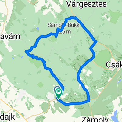
Gánti út - Gánti út
A cycling route starting in Zámoly, Fejér, Hungary.
Overview
About this route
- 42 min
- Duration
- 4.6 km
- Distance
- 88 m
- Ascent
- 140 m
- Descent
- 6.7 km/h
- Avg. speed
- 254 m
- Max. altitude

Continue with Bikemap
Use, edit, or download this cycling route
You would like to ride Gánti út - Gánti út or customize it for your own trip? Here is what you can do with this Bikemap route:
Free features
- Save this route as favorite or in collections
- Copy & plan your own version of this route
- Sync your route with Garmin or Wahoo
Premium features
Free trial for 3 days, or one-time payment. More about Bikemap Premium.
- Navigate this route on iOS & Android
- Export a GPX / KML file of this route
- Create your custom printout (try it for free)
- Download this route for offline navigation
Discover more Premium features.
Get Bikemap PremiumFrom our community
Other popular routes starting in Zámoly
 Vértes 2-es terv
- Distance
- 42.1 km
- Ascent
- 469 m
- Descent
- 473 m
- Location
- Zámoly, Fejér, Hungary
 Vértes első terv
- Distance
- 32.5 km
- Ascent
- 504 m
- Descent
- 504 m
- Location
- Zámoly, Fejér, Hungary
 Vértes alsó kör
- Distance
- 50.5 km
- Ascent
- 647 m
- Descent
- 647 m
- Location
- Zámoly, Fejér, Hungary
 2014 06 16 Csakberény 31.55 km
- Distance
- 30.8 km
- Ascent
- 391 m
- Descent
- 394 m
- Location
- Zámoly, Fejér, Hungary
 Zitour
- Distance
- 27.8 km
- Ascent
- 62 m
- Descent
- 175 m
- Location
- Zámoly, Fejér, Hungary
 Vértesi túra
- Distance
- 56.9 km
- Ascent
- 390 m
- Descent
- 392 m
- Location
- Zámoly, Fejér, Hungary
 Vértes Csákberény-Csókakő
- Distance
- 14.5 km
- Ascent
- 302 m
- Descent
- 237 m
- Location
- Zámoly, Fejér, Hungary
 Vértes kör
- Distance
- 49.9 km
- Ascent
- 345 m
- Descent
- 345 m
- Location
- Zámoly, Fejér, Hungary
Open it in the app