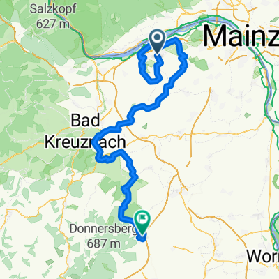
011u Ingelheim - Wendelsheim - Pfaffen Schwabenheim - Ingelheim
A cycling route starting in Ingelheim am Rhein, Rhineland-Palatinate, Germany.
Overview
About this route
Start- & Zielort: Tor 1
Ingelheim - Gau Algesheim - Appenheim - Nieder Hilbersheim - Ober Hilbersheim - Wolfsheim - Gau Weinheim - Wallertheim - Schimsheim - Armsheim - Flonheim - Uffhofen - Wendelsheim - Eckelsheim - Wöllstein - Badenheim - Pfaffen Schwabenheim - Sprendlingen - Col de Deponie - Ober Hilbersheim - Nieder Hilbersheim - Appenheim - Gau Algesheim - Ingelheim.
- -:--
- Duration
- 66.6 km
- Distance
- 374 m
- Ascent
- 308 m
- Descent
- ---
- Avg. speed
- 260 m
- Avg. speed
Route quality
Waytypes & surfaces along the route
Waytypes
Busy road
35.1 km
(53 %)
Quiet road
12 km
(18 %)
Surfaces
Paved
53.5 km
(80 %)
Unpaved
3.7 km
(6 %)
Asphalt
48.8 km
(73 %)
Paved (undefined)
2.1 km
(3 %)
Continue with Bikemap
Use, edit, or download this cycling route
You would like to ride 011u Ingelheim - Wendelsheim - Pfaffen Schwabenheim - Ingelheim or customize it for your own trip? Here is what you can do with this Bikemap route:
Free features
- Save this route as favorite or in collections
- Copy & plan your own version of this route
- Sync your route with Garmin or Wahoo
Premium features
Free trial for 3 days, or one-time payment. More about Bikemap Premium.
- Navigate this route on iOS & Android
- Export a GPX / KML file of this route
- Create your custom printout (try it for free)
- Download this route for offline navigation
Discover more Premium features.
Get Bikemap PremiumFrom our community
Other popular routes starting in Ingelheim am Rhein
- Ingelh-Walgalgesh-Windesh-Ingelh 3
- Distance
- 53 km
- Ascent
- 328 m
- Descent
- 327 m
- Location
- Ingelheim am Rhein, Rhineland-Palatinate, Germany
- 016d Ingelheim - Presberg - Bacharach - Rheinböllen - Stromberg - Ingelheim
- Distance
- 89.2 km
- Ascent
- 1,274 m
- Descent
- 1,258 m
- Location
- Ingelheim am Rhein, Rhineland-Palatinate, Germany
- 011u Ingelheim - Wendelsheim - Pfaffen Schwabenheim - Ingelheim
- Distance
- 66.6 km
- Ascent
- 374 m
- Descent
- 308 m
- Location
- Ingelheim am Rhein, Rhineland-Palatinate, Germany
- große Hunsrücktour II Ingelheim, Gemünden, Ingelheim (Variante)
- Distance
- 119.7 km
- Ascent
- 1,586 m
- Descent
- 1,533 m
- Location
- Ingelheim am Rhein, Rhineland-Palatinate, Germany
- 2016 - 4. Tag
- Distance
- 102.8 km
- Ascent
- 271 m
- Descent
- 312 m
- Location
- Ingelheim am Rhein, Rhineland-Palatinate, Germany
- 010c Ingelheim - Köngernheim - Undenheim - Ingelheim
- Distance
- 61 km
- Ascent
- 386 m
- Descent
- 325 m
- Location
- Ingelheim am Rhein, Rhineland-Palatinate, Germany
- Ingelheim - Guldental - Wallhausen - Mandel - Waldböckelheim - Odernheim - Bad Münster - Fürfeld - Sprendlingen - Ingelheim
- Distance
- 118.1 km
- Ascent
- 878 m
- Descent
- 876 m
- Location
- Ingelheim am Rhein, Rhineland-Palatinate, Germany
- "Üwwer die Schiersteiner Brück!"
- Distance
- 39.5 km
- Ascent
- 55 m
- Descent
- 55 m
- Location
- Ingelheim am Rhein, Rhineland-Palatinate, Germany
Open it in the app