Kleiner Buttenheimer Halbmarathon
A cycling route starting in Buttenheim, Bavaria, Germany.
Overview
About this route
At the beginning of the route, a slight climb, then field and forest paths, after Ketschendorf on a gravel path a nice 14% incline up to the height; the steep descent to Frankendorf is followed by about 4 km of ascent on the paved road to Kälberberg. Turn in Hochstall and continue on the paved road almost to Friesener Warte. Caution when descending towards Friesen - quite steep - turn left at the parking lot and then take the forest or gravel path to Friesen, cross the village and head towards Hirschaid on the main road. After the Wasserhaus, turn left and cross the Hirschaid -Seigendorf road, conquer a slight incline, and then follow the paved field path to Buttenheim. Duration: approx. 1 hour 45 minutes
- -:--
- Duration
- 22 km
- Distance
- 484 m
- Ascent
- 484 m
- Descent
- ---
- Avg. speed
- ---
- Max. altitude
Continue with Bikemap
Use, edit, or download this cycling route
You would like to ride Kleiner Buttenheimer Halbmarathon or customize it for your own trip? Here is what you can do with this Bikemap route:
Free features
- Save this route as favorite or in collections
- Copy & plan your own version of this route
- Sync your route with Garmin or Wahoo
Premium features
Free trial for 3 days, or one-time payment. More about Bikemap Premium.
- Navigate this route on iOS & Android
- Export a GPX / KML file of this route
- Create your custom printout (try it for free)
- Download this route for offline navigation
Discover more Premium features.
Get Bikemap PremiumFrom our community
Other popular routes starting in Buttenheim
- sonntagsrunde friesener warte
- Distance
- 9.6 km
- Ascent
- 460 m
- Descent
- 477 m
- Location
- Buttenheim, Bavaria, Germany
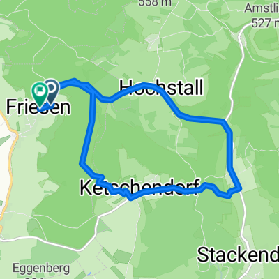
- Aussichtspunkt Walberla - Am Kanal - über Hallerndorf
- Distance
- 29.8 km
- Ascent
- 306 m
- Descent
- 306 m
- Location
- Buttenheim, Bavaria, Germany
- Brauerei- und Bierkellertour FO1
- Distance
- 35 km
- Ascent
- 335 m
- Descent
- 343 m
- Location
- Buttenheim, Bavaria, Germany
- Buttenheim-Burker Wald-Baggersee Altendorf
- Distance
- 40.2 km
- Ascent
- 275 m
- Descent
- 272 m
- Location
- Buttenheim, Bavaria, Germany
- Kanal-Strullendorf-Amlingstadt-Wernsdorf-Leesten-Friesen-Buttenheim
- Distance
- 25.5 km
- Ascent
- 305 m
- Descent
- 297 m
- Location
- Buttenheim, Bavaria, Germany
- Bamberg MTB 2
- Distance
- 43.8 km
- Ascent
- 1,038 m
- Descent
- 931 m
- Location
- Buttenheim, Bavaria, Germany
- Rundkurs Schießberg-Senftenberg-Almadler-Kalteneggolsfeld-TiefenstürmigKautschenberg-Gunzendorf-Dreuschendorf-Buttenheim
- Distance
- 31.7 km
- Ascent
- 593 m
- Descent
- 598 m
- Location
- Buttenheim, Bavaria, Germany
- Buttenheim-Strullendorfer Keller-RMD-Kanal-Hirschaid-Altendorf -Buttenheim
- Distance
- 18.2 km
- Ascent
- 140 m
- Descent
- 142 m
- Location
- Buttenheim, Bavaria, Germany
Open it in the app