

Night Ride
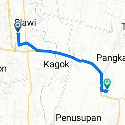
A cycling route starting in Slawi, Central Java, Indonesia.
Overview
About this route
- 2 h 28 min
- Duration
- 36.8 km
- Distance
- 105 m
- Ascent
- 126 m
- Descent
- 15 km/h
- Avg. speed
- 65 m
- Max. altitude

Route photos


Continue with Bikemap
Use, edit, or download this cycling route
You would like to ride Night Ride or customize it for your own trip? Here is what you can do with this Bikemap route:
Free features
- Save this route as favorite or in collections
- Copy & plan your own version of this route
- Sync your route with Garmin or Wahoo
Premium features
Free trial for 3 days, or one-time payment. More about Bikemap Premium.
- Navigate this route on iOS & Android
- Export a GPX / KML file of this route
- Create your custom printout (try it for free)
- Download this route for offline navigation
Discover more Premium features.
Get Bikemap PremiumFrom our community
Other popular routes starting in Slawi
 Jalan Gajah Mada, Kecamatan Slawi to Jalan Gajah Mada No.69, Kecamatan Slawi
- Distance
- 6.5 km
- Ascent
- 28 m
- Descent
- 43 m
- Location
- Slawi, Central Java, Indonesia
 Jalan Tengah, Kecamatan Pangkah to Gang 30, Kecamatan Slawi
- Distance
- 4.8 km
- Ascent
- 11 m
- Descent
- 49 m
- Location
- Slawi, Central Java, Indonesia
 Night Ride
- Distance
- 36.8 km
- Ascent
- 105 m
- Descent
- 126 m
- Location
- Slawi, Central Java, Indonesia
 24CQ+7R8, Kecamatan Slawi to Jalan Jenderal Ahmad Yani No.184, Kecamatan Slawi
- Distance
- 49.1 km
- Ascent
- 432 m
- Descent
- 430 m
- Location
- Slawi, Central Java, Indonesia
 Jalan KH. Mas Mansyur F50, Kecamatan Slawi to Jalan Merpati 1, Kecamatan Slawi
- Distance
- 26.4 km
- Ascent
- 151 m
- Descent
- 147 m
- Location
- Slawi, Central Java, Indonesia
 Jalan KH. Mas Mansyur F50, Kecamatan Slawi to Jalan Merpati 1, Kecamatan Slawi
- Distance
- 29.2 km
- Ascent
- 138 m
- Descent
- 138 m
- Location
- Slawi, Central Java, Indonesia
 Jalan Gajah Mada No.69, Kecamatan Slawi to Jalan Gajah Mada 69, Kecamatan Slawi
- Distance
- 4.9 km
- Ascent
- 23 m
- Descent
- 19 m
- Location
- Slawi, Central Java, Indonesia
 Gang 30, Kecamatan Slawi to Jalan Tengah, Kecamatan Pangkah
- Distance
- 4.7 km
- Ascent
- 24 m
- Descent
- 37 m
- Location
- Slawi, Central Java, Indonesia
Open it in the app