

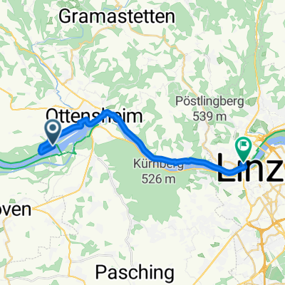
GIS - Variante
A cycling route starting in Ottensheim, Upper Austria, Austria.
Overview
About this route
A slightly longer variant on the GIS from the Ottensheim power plant.
- -:--
- Duration
- 59.8 km
- Distance
- 1,052 m
- Ascent
- 1,053 m
- Descent
- ---
- Avg. speed
- ---
- Max. altitude

Continue with Bikemap
Use, edit, or download this cycling route
You would like to ride GIS - Variante or customize it for your own trip? Here is what you can do with this Bikemap route:
Free features
- Save this route as favorite or in collections
- Copy & plan your own version of this route
- Sync your route with Garmin or Wahoo
Premium features
Free trial for 3 days, or one-time payment. More about Bikemap Premium.
- Navigate this route on iOS & Android
- Export a GPX / KML file of this route
- Create your custom printout (try it for free)
- Download this route for offline navigation
Discover more Premium features.
Get Bikemap PremiumFrom our community
Other popular routes starting in Ottensheim
 Ottensheim - Nöchling
- Distance
- 78.9 km
- Ascent
- 344 m
- Descent
- 400 m
- Location
- Ottensheim, Upper Austria, Austria
 GIS - Variante
- Distance
- 59.8 km
- Ascent
- 1,052 m
- Descent
- 1,053 m
- Location
- Ottensheim, Upper Austria, Austria
 Ottensheim - Schärding
- Distance
- 88.5 km
- Ascent
- 1,436 m
- Descent
- 1,396 m
- Location
- Ottensheim, Upper Austria, Austria
 Von Aigen-Schlägl bis Ottensheim
- Distance
- 51.4 km
- Ascent
- 1,237 m
- Descent
- 900 m
- Location
- Ottensheim, Upper Austria, Austria
 Wilhering bis Linz
- Distance
- 15.1 km
- Ascent
- 42 m
- Descent
- 43 m
- Location
- Ottensheim, Upper Austria, Austria
 erste mühlviertel-runde-jahr1993
- Distance
- 45.4 km
- Ascent
- 920 m
- Descent
- 914 m
- Location
- Ottensheim, Upper Austria, Austria
 Ottensheim nach Perg Hauptplatz
- Distance
- 47.2 km
- Ascent
- 75 m
- Descent
- 103 m
- Location
- Ottensheim, Upper Austria, Austria
 Ottensheim - Bad Kreuzen
- Distance
- 71.6 km
- Ascent
- 271 m
- Descent
- 299 m
- Location
- Ottensheim, Upper Austria, Austria
Open it in the app