
Leichte Samstag nachmittags Tour
A cycling route starting in Simmersfeld, Baden-Württemberg, Germany.
Overview
About this route
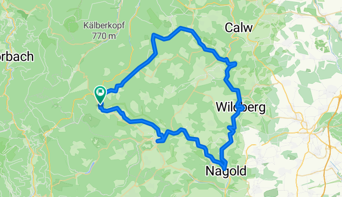
Von Simmersfeld ( Industriegebiet ) über Aichhalden nach Hofstett weiter über die alte Weinstrasse bis zur Kreuzung Schützenhaus Rötenbach nach Rötenbach dann über die Wolfsschlucht nach Bad Teinach und weiter ins Teinachtal bis zur Stadion Teinach. Auf dem Radweg nach Wildberg und Nagold. In Nagold dann über einen kleinen Hügel nach Rohrdorf.Weiter auf dem Radweg nach Altensteig. Am Kreisverkehr gleich rechts in die Oberstadt und weiter durch den Wald, nach Ettmansweiler am Friedhof vorbei, über die Strasse zum 3. Schilift zurück zum Anfangspunkt unserer Tour
- -:--
- Duration
- 70.6 km
- Distance
- 625 m
- Ascent
- 625 m
- Descent
- ---
- Avg. speed
- ---
- Max. altitude
Continue with Bikemap
Use, edit, or download this cycling route
You would like to ride Leichte Samstag nachmittags Tour or customize it for your own trip? Here is what you can do with this Bikemap route:
Free features
- Save this route as favorite or in collections
- Copy & plan your own version of this route
- Sync your route with Garmin or Wahoo
Premium features
Free trial for 3 days, or one-time payment. More about Bikemap Premium.
- Navigate this route on iOS & Android
- Export a GPX / KML file of this route
- Create your custom printout (try it for free)
- Download this route for offline navigation
Discover more Premium features.
Get Bikemap PremiumFrom our community
Other popular routes starting in Simmersfeld
 simmersfeld56
- Distance
- 56.1 km
- Ascent
- 932 m
- Descent
- 931 m
- Location
- Simmersfeld, Baden-Württemberg, Germany
 2019 Tag2 Besenfeld - Hornisgrinde (Mummelsee)
- Distance
- 60.3 km
- Ascent
- 1,167 m
- Descent
- 1,167 m
- Location
- Simmersfeld, Baden-Württemberg, Germany
 Nagold Enz
- Distance
- 99.4 km
- Ascent
- 91 m
- Descent
- 655 m
- Location
- Simmersfeld, Baden-Württemberg, Germany
 rwgps-ebhausen110
- Distance
- 110.3 km
- Ascent
- 1,595 m
- Descent
- 1,594 m
- Location
- Simmersfeld, Baden-Württemberg, Germany
 Besenfeld - Freudenstadt- Wolfach - Mühlenbach (Blackforest 2)
- Distance
- 76.2 km
- Ascent
- 554 m
- Descent
- 1,082 m
- Location
- Simmersfeld, Baden-Württemberg, Germany
 Leichte Samstag nachmittags Tour
- Distance
- 70.6 km
- Ascent
- 625 m
- Descent
- 625 m
- Location
- Simmersfeld, Baden-Württemberg, Germany
 Simmersfeld - Meersburg - Singen
- Distance
- 253.7 km
- Ascent
- 1,040 m
- Descent
- 1,359 m
- Location
- Simmersfeld, Baden-Württemberg, Germany
 Nagoldtalradweg - Urnagold - (Calw) Pforzheim
- Distance
- 125.4 km
- Ascent
- 2,242 m
- Descent
- 2,468 m
- Location
- Simmersfeld, Baden-Württemberg, Germany
Open it in the app