
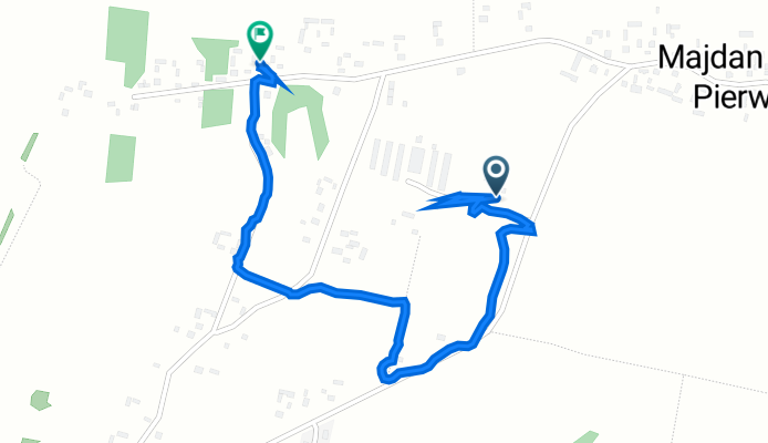
Długa 41, Majdan Górny do Niwa 48, Majdan Górny
A cycling route starting in Tomaszów Lubelski, Lublin Voivodeship, Poland.
Overview
About this route
- 8 min
- Duration
- 1.6 km
- Distance
- 38 m
- Ascent
- 34 m
- Descent
- 13.1 km/h
- Avg. speed
- 311 m
- Avg. speed

Continue with Bikemap
Use, edit, or download this cycling route
You would like to ride Długa 41, Majdan Górny do Niwa 48, Majdan Górny or customize it for your own trip? Here is what you can do with this Bikemap route:
Free features
- Save this route as favorite or in collections
- Copy & plan your own version of this route
- Sync your route with Garmin or Wahoo
Premium features
Free trial for 3 days, or one-time payment. More about Bikemap Premium.
- Navigate this route on iOS & Android
- Export a GPX / KML file of this route
- Create your custom printout (try it for free)
- Download this route for offline navigation
Discover more Premium features.
Get Bikemap PremiumFrom our community
Other popular routes starting in Tomaszów Lubelski
 X etap Bałżec - Jarosław
- Distance
- 97.8 km
- Ascent
- 282 m
- Descent
- 342 m
- Location
- Tomaszów Lubelski, Lublin Voivodeship, Poland
 RAJD GREEN VELO - JESIEŃ 2017
- Distance
- 127.5 km
- Ascent
- 246 m
- Descent
- 305 m
- Location
- Tomaszów Lubelski, Lublin Voivodeship, Poland
 Tomaszów Lubelski
- Distance
- 31.4 km
- Ascent
- 113 m
- Descent
- 114 m
- Location
- Tomaszów Lubelski, Lublin Voivodeship, Poland
 Trasa 1 - Tomaszów- Łosiniec-Podlesina-Tomaszów
- Distance
- 20.3 km
- Ascent
- 172 m
- Descent
- 172 m
- Location
- Tomaszów Lubelski, Lublin Voivodeship, Poland
 Południowa 4–4C, Tomaszów Lubelski do Leśna, Tomaszów Lubelski
- Distance
- 10 km
- Ascent
- 56 m
- Descent
- 55 m
- Location
- Tomaszów Lubelski, Lublin Voivodeship, Poland
 Tomaszów Lubelski - Ostrowiec Świętokrzyski
- Distance
- 198 km
- Ascent
- 417 m
- Descent
- 516 m
- Location
- Tomaszów Lubelski, Lublin Voivodeship, Poland
 Leśna 13, Tomaszów Lubelski do Leśna 13, Tomaszów Lubelski
- Distance
- 37.5 km
- Ascent
- 203 m
- Descent
- 231 m
- Location
- Tomaszów Lubelski, Lublin Voivodeship, Poland
 Tomaszów Lubelski - Bike'owe Roztocze
- Distance
- 71 km
- Ascent
- 571 m
- Descent
- 572 m
- Location
- Tomaszów Lubelski, Lublin Voivodeship, Poland
Open it in the app