

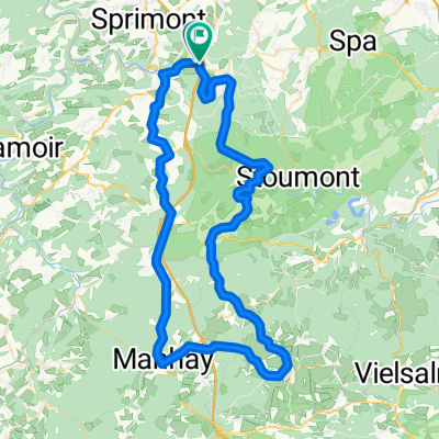
Ardennen offensief
A cycling route starting in Aywaille, Wallonia, Belgium.
Overview
About this route
Ardennen offensief
- -:--
- Duration
- 86 km
- Distance
- 1,627 m
- Ascent
- 1,627 m
- Descent
- ---
- Avg. speed
- 471 m
- Max. altitude

Route quality
Waytypes & surfaces along the route
Waytypes
Road
55.9 km
(65 %)
Quiet road
21.5 km
(25 %)
Surfaces
Paved
37.8 km
(44 %)
Asphalt
36.1 km
(42 %)
Concrete
1.7 km
(2 %)
Undefined
48.2 km
(56 %)
Route highlights
Points of interest along the route
Point of interest after 2 km
La redoute - https://climbfinder.com/nl/beklimmingen/redoute
Point of interest after 11 km
Chambralles - https://climbfinder.com/nl/beklimmingen/chambralles
Point of interest after 19 km
Col de Mont via Comblain au Pont -> https://climbfinder.com/nl/beklimmingen/cote-de-mont-comblain-au-pont
Point of interest after 35.4 km
Côte de Xhoris via Comblinay -> https://climbfinder.com/nl/beklimmingen/cote-de-xhoris-comblinay
Drinking water after 47.4 km
mogelijk stopje -> woe vanaf 12u00... https://www.google.com/maps/place/Le+Hibou/@50.3826109,5.577511,16z/data=!4m15!1m8!3m7!1s0x47c044dfac10330f:0x114da5818478b527!2sRue+du+Mill%C3%A9naire,+6941+Durbuy!3b1!8m2!3d50.361792!4d5.5803829!16s%2Fg%2F1v4k5nfy!3m5!1s0x47c05b2d27dcf8b7:0xe11363cc22704872!8m2!3d50.380033!4d5.591379!16s%2Fg%2F11bt_h4vty?entry=ttu
Drinking water after 52.3 km
Mogelijk koffiehuis... https://www.google.com/maps/place/Amon+L'Hermitte/@50.3611179,5.5777444,18z/data=!4m10!1m2!2m1!1scafe!3m6!1s0x47c044df9849c9af:0xedc64793f18900e7!8m2!3d50.3612414!4d5.5794686!15sCgRjYWZlWgYiBGNhZmWSAQtjb2ZmZWVfc2hvcOABAA!16s%2Fg%2F11c6pmyn2w?entry=ttu
Drinking water after 54.1 km
Mogelijke pitsstop - koffie en gebak
Point of interest after 64.2 km
Beklimming Izier naar Bru - geen hoogteprofiel - naar hoogste punt van route 470m.
Point of interest after 73.8 km
Cote de Lorcé -> https://climbfinder.com/nl/beklimmingen/lorce
Drinking water after 83.4 km
Mogelijke eindstop : https://www.google.com/maps/place/La+Cafet+Aywaille/@50.4755593,5.6772631,17z/data=!4m10!1m2!2m1!1scafe!3m6!1s0x47c05fced99f587b:0xf4a3f88e6461d38f!8m2!3d50.4755593!4d5.6790838!15sCgRjYWZlWgYiBGNhZmWSARRyZXN0YXVyYW50X2JyYXNzZXJpZeABAA!16s%2Fg%2F11tf1t1b_7?entry=ttu
Continue with Bikemap
Use, edit, or download this cycling route
You would like to ride Ardennen offensief or customize it for your own trip? Here is what you can do with this Bikemap route:
Free features
- Save this route as favorite or in collections
- Copy & plan your own version of this route
- Split it into stages to create a multi-day tour
- Sync your route with Garmin or Wahoo
Premium features
Free trial for 3 days, or one-time payment. More about Bikemap Premium.
- Navigate this route on iOS & Android
- Export a GPX / KML file of this route
- Create your custom printout (try it for free)
- Download this route for offline navigation
Discover more Premium features.
Get Bikemap PremiumFrom our community
Other popular routes starting in Aywaille
 Tour de Spa & Stavelot
- Distance
- 95.5 km
- Ascent
- 2,001 m
- Descent
- 1,838 m
- Location
- Aywaille, Wallonia, Belgium
 Côtes de la vallée de l'Amblève
- Distance
- 79.2 km
- Ascent
- 1,275 m
- Descent
- 1,273 m
- Location
- Aywaille, Wallonia, Belgium
 Linglinspo 28K
- Distance
- 28.7 km
- Ascent
- 961 m
- Descent
- 967 m
- Location
- Aywaille, Wallonia, Belgium
 Sykkeltur2019
- Distance
- 53.9 km
- Ascent
- 921 m
- Descent
- 918 m
- Location
- Aywaille, Wallonia, Belgium
 Arbelette
- Distance
- 309.9 km
- Ascent
- 2,048 m
- Descent
- 2,059 m
- Location
- Aywaille, Wallonia, Belgium
 Team Gessel - Rondje Luik
- Distance
- 94.7 km
- Ascent
- 1,206 m
- Descent
- 1,206 m
- Location
- Aywaille, Wallonia, Belgium
 Ardennen2015-aywaille2
- Distance
- 84.5 km
- Ascent
- 1,323 m
- Descent
- 1,315 m
- Location
- Aywaille, Wallonia, Belgium
 An petit tour
- Distance
- 71.5 km
- Ascent
- 910 m
- Descent
- 907 m
- Location
- Aywaille, Wallonia, Belgium
Open it in the app