kikitrip - N°02
A cycling route starting in Châtillon-en-Michaille, Auvergne-Rhône-Alpes, France.
Overview
About this route
- -:--
- Duration
- 40.1 km
- Distance
- 942 m
- Ascent
- 847 m
- Descent
- ---
- Avg. speed
- 1,242 m
- Avg. speed
Route quality
Waytypes & surfaces along the route
Waytypes
Busy road
24.2 km
(60 %)
Quiet road
10.4 km
(26 %)
Surfaces
Paved
27.5 km
(69 %)
Unpaved
0.6 km
(2 %)
Asphalt
27.5 km
(69 %)
Ground
0.6 km
(2 %)
Undefined
12 km
(30 %)
Route highlights
Points of interest along the route
Point of interest after 11.4 km
Pont népalais
Point of interest after 12 km
Tunnel problématique
Point of interest after 37.5 km
Continue with Bikemap
Use, edit, or download this cycling route
You would like to ride kikitrip - N°02 or customize it for your own trip? Here is what you can do with this Bikemap route:
Free features
- Save this route as favorite or in collections
- Copy & plan your own version of this route
- Sync your route with Garmin or Wahoo
Premium features
Free trial for 3 days, or one-time payment. More about Bikemap Premium.
- Navigate this route on iOS & Android
- Export a GPX / KML file of this route
- Create your custom printout (try it for free)
- Download this route for offline navigation
Discover more Premium features.
Get Bikemap PremiumFrom our community
Other popular routes starting in Châtillon-en-Michaille
- TRAVJURA
- Distance
- 137.1 km
- Ascent
- 1,606 m
- Descent
- 1,781 m
- Location
- Châtillon-en-Michaille, Auvergne-Rhône-Alpes, France
- Giron / Bellegarde
- Distance
- 21.7 km
- Ascent
- 338 m
- Descent
- 972 m
- Location
- Châtillon-en-Michaille, Auvergne-Rhône-Alpes, France
- Relaxed route in Bellegarde-sur-Valserine
- Distance
- 7 km
- Ascent
- 76 m
- Descent
- 177 m
- Location
- Châtillon-en-Michaille, Auvergne-Rhône-Alpes, France
- Cols Cuvery and Richemond
- Distance
- 51.2 km
- Ascent
- 918 m
- Descent
- 1,018 m
- Location
- Châtillon-en-Michaille, Auvergne-Rhône-Alpes, France
- Tour du plateau de Retord
- Distance
- 73.6 km
- Ascent
- 1,616 m
- Descent
- 1,407 m
- Location
- Châtillon-en-Michaille, Auvergne-Rhône-Alpes, France
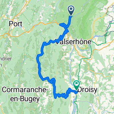
- Le grand colombier aller et retour
- Distance
- 89.8 km
- Ascent
- 2,280 m
- Descent
- 2,146 m
- Location
- Châtillon-en-Michaille, Auvergne-Rhône-Alpes, France
- kikitrip - N°02
- Distance
- 40.1 km
- Ascent
- 942 m
- Descent
- 847 m
- Location
- Châtillon-en-Michaille, Auvergne-Rhône-Alpes, France
- CIRQUE des AVALANCHES, por Champfromier
- Distance
- 4.5 km
- Ascent
- 541 m
- Descent
- 32 m
- Location
- Châtillon-en-Michaille, Auvergne-Rhône-Alpes, France
Open it in the app