

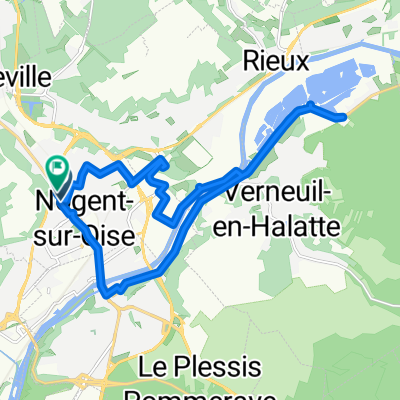
32 Place du Général de Gaulle, Creil à 12 Place du Parvis Notre-Dame, Senlis
A cycling route starting in Nogent-sur-Oise, Hauts-de-France, France.
Overview
About this route
- 47 min
- Duration
- 12 km
- Distance
- 104 m
- Ascent
- 58 m
- Descent
- 15.4 km/h
- Avg. speed
- 96 m
- Max. altitude
Route quality
Waytypes & surfaces along the route
Waytypes
Quiet road
1.2 km
(10 %)
Living street
0.7 km
(6 %)
Surfaces
Paved
7.7 km
(64 %)
Asphalt
7 km
(58 %)
Paved (undefined)
0.7 km
(6 %)
Undefined
4.3 km
(36 %)
Continue with Bikemap
Use, edit, or download this cycling route
You would like to ride 32 Place du Général de Gaulle, Creil à 12 Place du Parvis Notre-Dame, Senlis or customize it for your own trip? Here is what you can do with this Bikemap route:
Free features
- Save this route as favorite or in collections
- Copy & plan your own version of this route
- Sync your route with Garmin or Wahoo
Premium features
Free trial for 3 days, or one-time payment. More about Bikemap Premium.
- Navigate this route on iOS & Android
- Export a GPX / KML file of this route
- Create your custom printout (try it for free)
- Download this route for offline navigation
Discover more Premium features.
Get Bikemap PremiumFrom our community
Other popular routes starting in Nogent-sur-Oise
 Creil-Havre
- Distance
- 285.1 km
- Ascent
- 1,935 m
- Descent
- 1,956 m
- Location
- Nogent-sur-Oise, Hauts-de-France, France
 Creil - Pierrefonds
- Distance
- 80.8 km
- Ascent
- 337 m
- Descent
- 264 m
- Location
- Nogent-sur-Oise, Hauts-de-France, France
 Recovered Route
- Distance
- 11.9 km
- Ascent
- 145 m
- Descent
- 115 m
- Location
- Nogent-sur-Oise, Hauts-de-France, France
 Creil-Fécamp
- Distance
- 300 km
- Ascent
- 623 m
- Descent
- 568 m
- Location
- Nogent-sur-Oise, Hauts-de-France, France
 Essone - 80km
- Distance
- 79.2 km
- Ascent
- 259 m
- Descent
- 237 m
- Location
- Nogent-sur-Oise, Hauts-de-France, France
 Boulevard Branly, Nogent-sur-Oise à Boulevard Branly, Nogent-sur-Oise
- Distance
- 18.6 km
- Ascent
- 85 m
- Descent
- 84 m
- Location
- Nogent-sur-Oise, Hauts-de-France, France
 32 Place du Général de Gaulle, Creil à 12 Place du Parvis Notre-Dame, Senlis
- Distance
- 12 km
- Ascent
- 104 m
- Descent
- 58 m
- Location
- Nogent-sur-Oise, Hauts-de-France, France
 a l'aventure
- Distance
- 35.5 km
- Ascent
- 429 m
- Descent
- 423 m
- Location
- Nogent-sur-Oise, Hauts-de-France, France
Open it in the app