

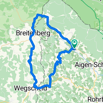
Schöneben-Plöckensteinersee
A cycling route starting in Ulrichsberg, Upper Austria, Austria.
Overview
About this route
Schöneben, Hochficht, Grenzübergang Plöckenstein, CZ bis Abzweigung links bei Raststation, Plöckensteinersee gleicher Weg zurück, dann Hirschtaltunnel am Schwarzenberger Schwemmkanal bis nach Glöcklberg anschließend auf der Straße bis nach Schöneben.
- -:--
- Duration
- 47.4 km
- Distance
- 785 m
- Ascent
- 796 m
- Descent
- ---
- Avg. speed
- 1,102 m
- Max. altitude

Route quality
Waytypes & surfaces along the route
Waytypes
Track
41.4 km
(87 %)
Road
3.3 km
(7 %)
Surfaces
Paved
28.3 km
(60 %)
Unpaved
14.8 km
(31 %)
Paved (undefined)
17.5 km
(37 %)
Gravel
14.5 km
(31 %)
Continue with Bikemap
Use, edit, or download this cycling route
You would like to ride Schöneben-Plöckensteinersee or customize it for your own trip? Here is what you can do with this Bikemap route:
Free features
- Save this route as favorite or in collections
- Copy & plan your own version of this route
- Sync your route with Garmin or Wahoo
Premium features
Free trial for 3 days, or one-time payment. More about Bikemap Premium.
- Navigate this route on iOS & Android
- Export a GPX / KML file of this route
- Create your custom printout (try it for free)
- Download this route for offline navigation
Discover more Premium features.
Get Bikemap PremiumFrom our community
Other popular routes starting in Ulrichsberg
 Lusweg 7, Klaffer am Hochficht nach Lusweg 5, Klaffer am Hochficht
- Distance
- 0.2 km
- Ascent
- 0 m
- Descent
- 0 m
- Location
- Ulrichsberg, Upper Austria, Austria
 Moldaustausee-Cesky Krumlovrunde
- Distance
- 94.1 km
- Ascent
- 1,099 m
- Descent
- 1,099 m
- Location
- Ulrichsberg, Upper Austria, Austria
 Route in Ulrichsberg
- Distance
- 67.4 km
- Ascent
- 1,303 m
- Descent
- 1,304 m
- Location
- Ulrichsberg, Upper Austria, Austria
 Schwarzenberg-Julbachrunde
- Distance
- 48.3 km
- Ascent
- 776 m
- Descent
- 776 m
- Location
- Ulrichsberg, Upper Austria, Austria
 Breitenberg - Cerneho jezera 105 km
- Distance
- 104.8 km
- Ascent
- 2,344 m
- Descent
- 1,991 m
- Location
- Ulrichsberg, Upper Austria, Austria
 Schwarzenberg Schwemmkanal
- Distance
- 71.2 km
- Ascent
- 490 m
- Descent
- 484 m
- Location
- Ulrichsberg, Upper Austria, Austria
 Home - Hochficht - Home
- Distance
- 27.3 km
- Ascent
- 808 m
- Descent
- 809 m
- Location
- Ulrichsberg, Upper Austria, Austria
 Plöckenstein-See-Runde
- Distance
- 41.1 km
- Ascent
- 835 m
- Descent
- 860 m
- Location
- Ulrichsberg, Upper Austria, Austria
Open it in the app