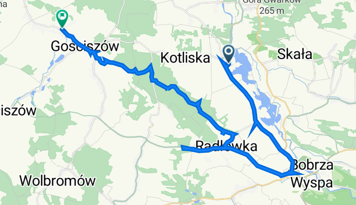
Trasa z 47A, Rakowice Ma艂e
A cycling route starting in Gmina Lw贸wek 艢l膮ski, Lower Silesian Voivodeship, Poland.
Overview
About this route
- 4 h 36 min
- Duration
- 27.8 km
- Distance
- 244 m
- Ascent
- 292 m
- Descent
- 6 km/h
- Avg. speed
- 287 m
- Max. altitude
Route quality
Waytypes & surfaces along the route
Waytypes
Road
12.8 km
(46 %)
Track
10.9 km
(39 %)
Surfaces
Paved
16.7 km
(60 %)
Unpaved
4.5 km
(16 %)
Asphalt
16.1 km
(58 %)
Gravel
4.5 km
(16 %)
Continue with Bikemap
Use, edit, or download this cycling route
You would like to ride Trasa z 47A, Rakowice Ma艂e or customize it for your own trip? Here is what you can do with this Bikemap route:
Free features
- Save this route as favorite or in collections
- Copy & plan your own version of this route
- Sync your route with Garmin or Wahoo
Premium features
Free trial for 3 days, or one-time payment. More about Bikemap Premium.
- Navigate this route on iOS & Android
- Export a GPX / KML file of this route
- Create your custom printout (try it for free)
- Download this route for offline navigation
Discover more Premium features.
Get Bikemap PremiumFrom our community
Other popular routes starting in Gmina Lw贸wek 艢l膮ski
Lw贸wek 艢l膮ski-Pielgrzymka- Distance
- 21.7 km
- Ascent
- 257 m
- Descent
- 257 m
- Location
- Gmina Lw贸wek 艢l膮ski, Lower Silesian Voivodeship, Poland
Route to Pilchowice Zapora- Distance
- 22.7 km
- Ascent
- 438 m
- Descent
- 357 m
- Location
- Gmina Lw贸wek 艢l膮ski, Lower Silesian Voivodeship, Poland
W艂odzice Wielkie do W艂odzice Wielkie- Distance
- 32.3 km
- Ascent
- 297 m
- Descent
- 318 m
- Location
- Gmina Lw贸wek 艢l膮ski, Lower Silesian Voivodeship, Poland
Untitled route- Distance
- 39.5 km
- Ascent
- 626 m
- Descent
- 336 m
- Location
- Gmina Lw贸wek 艢l膮ski, Lower Silesian Voivodeship, Poland
St贸g izerski- Distance
- 118.3 km
- Ascent
- 1,221 m
- Descent
- 1,221 m
- Location
- Gmina Lw贸wek 艢l膮ski, Lower Silesian Voivodeship, Poland
Lw贸wek 艢l膮ski - Lubomierz - Wle艅 - Lw贸wek 艢l膮ski- Distance
- 46 km
- Ascent
- 472 m
- Descent
- 477 m
- Location
- Gmina Lw贸wek 艢l膮ski, Lower Silesian Voivodeship, Poland
LBobr_Lwowek_Boleslawiec- Distance
- 22 km
- Ascent
- 123 m
- Descent
- 143 m
- Location
- Gmina Lw贸wek 艢l膮ski, Lower Silesian Voivodeship, Poland
Lwowek Slaski - Wlen - Gryfow Slaski - Lwowek Slaski- Distance
- 90.8 km
- Ascent
- 1,156 m
- Descent
- 1,157 m
- Location
- Gmina Lw贸wek 艢l膮ski, Lower Silesian Voivodeship, Poland
Open it in the app


