
3 passi. Valles, San Pellegrino, Lusia.
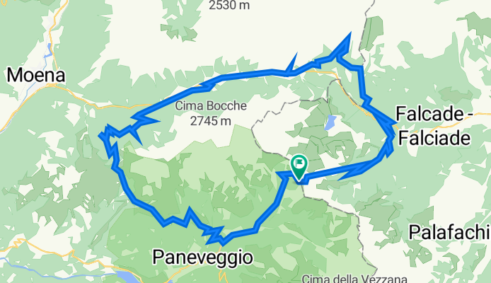
A cycling route starting in Falcade, Veneto, Italy.
Overview
About this route
Giro molto bello, un po impegnativo fisicamente, con un pezzo critico in cui si deve scendere a spingere la bici su una ripida salita. Si parte dal Passo Valles, si arriva quasi a Falcade. Poco prima di entrare in Falcade alto in località Le Fratte si gira a sinistra su una strada forestale e si comincia a salire. Dopo poco più di un chilometro la forestale si trasforma in un sentiero sconnesso, ripido e non pedalabile. Questo è il punto critico di tutto il giro. Bisogna scendere e spingere la bici per circa un chilometro. Ne vale va pena. Il sentiero diviene di nuovo pedalabile mentre costeggia il torrente Biois, poi siamo su asfalto fino a Fuciade, spettacolare! Da Fuciade in leggera discesa fino al Passo di San Pellegrino. Scendiano sulla strada verso Moena per circa 4 km, poi per una bella forestale continuiamo a scendere fino a quota 1.600 mt. per poi salire su bella forestale fino al rifugio Rezila a 1.760 mt. Sempre su una buona forestale pedalabile fino al Rifugio Lusia a 2056 mt. Scendiamo in pieno relax fino a Malga Bocche. Ora scendiamo verso la strada del passo Valles. Poco dopo Malga Bocche il sentiero diventa piuttosto impervio. Bisogna fare circa 6-700 metri a piedi, ma in discesa non ci sono problemi, dopo di che una comoda forestale ci porta sulla strada del passo e da li si rientra al passo Valles.
- 5 h 29 min
- Duration
- 46.2 km
- Distance
- 1,648 m
- Ascent
- 1,653 m
- Descent
- 8.4 km/h
- Avg. speed
- 2,053 m
- Max. altitude
Route quality
Waytypes & surfaces along the route
Waytypes
Track
24.8 km
(54 %)
Busy road
13.8 km
(30 %)
Surfaces
Paved
11.1 km
(24 %)
Unpaved
17.9 km
(39 %)
Gravel
15.6 km
(34 %)
Asphalt
9.2 km
(20 %)
Continue with Bikemap
Use, edit, or download this cycling route
You would like to ride 3 passi. Valles, San Pellegrino, Lusia. or customize it for your own trip? Here is what you can do with this Bikemap route:
Free features
- Save this route as favorite or in collections
- Copy & plan your own version of this route
- Sync your route with Garmin or Wahoo
Premium features
Free trial for 3 days, or one-time payment. More about Bikemap Premium.
- Navigate this route on iOS & Android
- Export a GPX / KML file of this route
- Create your custom printout (try it for free)
- Download this route for offline navigation
Discover more Premium features.
Get Bikemap PremiumFrom our community
Other popular routes starting in Falcade
 09072013 falcade - bozen
- Distance
- 159.3 km
- Ascent
- 3,052 m
- Descent
- 4,007 m
- Location
- Falcade, Veneto, Italy
 Falcade - Alleghe - Passo Staulanza - Longarone - Pieve di Cadore
- Distance
- 92.7 km
- Ascent
- 1,887 m
- Descent
- 2,154 m
- Location
- Falcade, Veneto, Italy
 Baita Segantini, anello
- Distance
- 11.9 km
- Ascent
- 480 m
- Descent
- 464 m
- Location
- Falcade, Veneto, Italy
 Italské Alpy 2008 - Trasa 2 (Falcade - Torcegno)
- Distance
- 88.6 km
- Ascent
- 2,558 m
- Descent
- 2,995 m
- Location
- Falcade, Veneto, Italy
 Pian dei Casoni - Baita Segantini
- Distance
- 7.3 km
- Ascent
- 506 m
- Descent
- 4 m
- Location
- Falcade, Veneto, Italy
 20130711 falcade - falcade
- Distance
- 108.5 km
- Ascent
- 2,366 m
- Descent
- 2,366 m
- Location
- Falcade, Veneto, Italy
 4. Etappe über Forcella Franche-Val del Mis
- Distance
- 158.7 km
- Ascent
- 902 m
- Descent
- 2,082 m
- Location
- Falcade, Veneto, Italy
 Giro Juribello Malga Venegia
- Distance
- 9.7 km
- Ascent
- 411 m
- Descent
- 409 m
- Location
- Falcade, Veneto, Italy
Open it in the app