

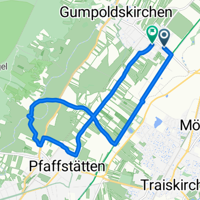
Richardhof 248, Gumpoldskirchen to Richardhof 248, Gumpoldskirchen
A cycling route starting in Gumpoldskirchen, Lower Austria, Austria.
Overview
About this route
- 4 h 15 min
- Duration
- 24.4 km
- Distance
- 879 m
- Ascent
- 877 m
- Descent
- 5.7 km/h
- Avg. speed
- 654 m
- Max. altitude

Route quality
Waytypes & surfaces along the route
Waytypes
Track
14.9 km
(61 %)
Path
4.9 km
(20 %)
Surfaces
Paved
5.1 km
(21 %)
Unpaved
18.3 km
(75 %)
Ground
7.6 km
(31 %)
Loose gravel
5.9 km
(24 %)
Continue with Bikemap
Use, edit, or download this cycling route
You would like to ride Richardhof 248, Gumpoldskirchen to Richardhof 248, Gumpoldskirchen or customize it for your own trip? Here is what you can do with this Bikemap route:
Free features
- Save this route as favorite or in collections
- Copy & plan your own version of this route
- Sync your route with Garmin or Wahoo
Premium features
Free trial for 3 days, or one-time payment. More about Bikemap Premium.
- Navigate this route on iOS & Android
- Export a GPX / KML file of this route
- Create your custom printout (try it for free)
- Download this route for offline navigation
Discover more Premium features.
Get Bikemap PremiumFrom our community
Other popular routes starting in Gumpoldskirchen
 Richardhof 248, Gumpoldskirchen to Richardhof 248, Gumpoldskirchen
- Distance
- 24.4 km
- Ascent
- 879 m
- Descent
- 877 m
- Location
- Gumpoldskirchen, Lower Austria, Austria
 Gumpoldskirchen Triestengau Radweg
- Distance
- 21.6 km
- Ascent
- 31 m
- Descent
- 82 m
- Location
- Gumpoldskirchen, Lower Austria, Austria
 Badgasse 54, Gumpoldskirchen nach Jubiläumspark 4, Mödling
- Distance
- 7.9 km
- Ascent
- 119 m
- Descent
- 55 m
- Location
- Gumpoldskirchen, Lower Austria, Austria
 Josef Schöffel-Straße 9, Gumpoldskirchen do Rotes Mäuerl 270, Gumpoldskirchen
- Distance
- 14.4 km
- Ascent
- 483 m
- Descent
- 484 m
- Location
- Gumpoldskirchen, Lower Austria, Austria
 Gumpoldskirchen EV9 und Triestingau
- Distance
- 40.7 km
- Ascent
- 111 m
- Descent
- 125 m
- Location
- Gumpoldskirchen, Lower Austria, Austria
 Von Gumpoldskirchen bis Sankt Margarethen im Burgenland
- Distance
- 63.9 km
- Ascent
- 404 m
- Descent
- 464 m
- Location
- Gumpoldskirchen, Lower Austria, Austria
 Rotes Mäuerl 270, Gumpoldskirchen nach Untere Ortsstraße 16, Achau
- Distance
- 11.8 km
- Ascent
- 55 m
- Descent
- 153 m
- Location
- Gumpoldskirchen, Lower Austria, Austria
 Wienerstraße, Gumpoldskirchen nach Wienerstraße, Gumpoldskirchen
- Distance
- 9.6 km
- Ascent
- 80 m
- Descent
- 79 m
- Location
- Gumpoldskirchen, Lower Austria, Austria
Open it in the app