

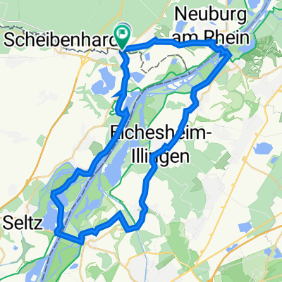
boucle neulauterbourg + ferries
A cycling route starting in Berg, Rhineland-Palatinate, Germany.
Overview
About this route
- -:--
- Duration
- 38.4 km
- Distance
- 75 m
- Ascent
- 78 m
- Descent
- ---
- Avg. speed
- 121 m
- Max. altitude

Route quality
Waytypes & surfaces along the route
Waytypes
Track
12.9 km
(34 %)
Cycleway
7.5 km
(19 %)
Surfaces
Paved
33.2 km
(86 %)
Unpaved
3.5 km
(9 %)
Asphalt
32.2 km
(84 %)
Gravel
2.9 km
(8 %)
Continue with Bikemap
Use, edit, or download this cycling route
You would like to ride boucle neulauterbourg + ferries or customize it for your own trip? Here is what you can do with this Bikemap route:
Free features
- Save this route as favorite or in collections
- Copy & plan your own version of this route
- Sync your route with Garmin or Wahoo
Premium features
Free trial for 3 days, or one-time payment. More about Bikemap Premium.
- Navigate this route on iOS & Android
- Export a GPX / KML file of this route
- Create your custom printout (try it for free)
- Download this route for offline navigation
Discover more Premium features.
Get Bikemap PremiumFrom our community
Other popular routes starting in Berg
 boucle neulauterbourg + ferries
- Distance
- 38.4 km
- Ascent
- 75 m
- Descent
- 78 m
- Location
- Berg, Rhineland-Palatinate, Germany
 Rheinweg Scheibenhardt-Kehl
- Distance
- 63.5 km
- Ascent
- 78 m
- Descent
- 54 m
- Location
- Berg, Rhineland-Palatinate, Germany
 Neulauterburg-Winden-Kandel-Wörth-Neulauterburg
- Distance
- 44.2 km
- Ascent
- 102 m
- Descent
- 100 m
- Location
- Berg, Rhineland-Palatinate, Germany
 Rheinweg Lauterbourg - Strasbourg CLONED FROM ROUTE 591189
- Distance
- 66.4 km
- Ascent
- 81 m
- Descent
- 50 m
- Location
- Berg, Rhineland-Palatinate, Germany
 Lautertal zur Dicken Eiche
- Distance
- 56 km
- Ascent
- 456 m
- Descent
- 158 m
- Location
- Berg, Rhineland-Palatinate, Germany
 Lauterbourg - Weißenburg
- Distance
- 23.8 km
- Ascent
- 71 m
- Descent
- 27 m
- Location
- Berg, Rhineland-Palatinate, Germany
 Von Lauterbourg bis Weißenburg
- Distance
- 21.2 km
- Ascent
- 74 m
- Descent
- 27 m
- Location
- Berg, Rhineland-Palatinate, Germany
 Schleital-Steinfeld-Hirschbrunnen
- Distance
- 37.4 km
- Ascent
- 80 m
- Descent
- 79 m
- Location
- Berg, Rhineland-Palatinate, Germany
Open it in the app