
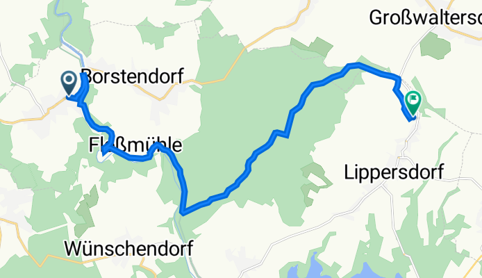
Alte Leitstraße 1, Grünhainichen nach Hauptstraße 161, Pockau-Lengefeld
A cycling route starting in Grünhainichen, Saxony, Germany.
Overview
About this route
- 53 min
- Duration
- 13 km
- Distance
- 259 m
- Ascent
- 129 m
- Descent
- 14.7 km/h
- Avg. speed
- 559 m
- Max. altitude
Route quality
Waytypes & surfaces along the route
Waytypes
Track
5.7 km
(44 %)
Quiet road
5.4 km
(42 %)
Surfaces
Paved
8 km
(61 %)
Unpaved
3.4 km
(26 %)
Asphalt
8 km
(61 %)
Gravel
2.6 km
(20 %)
Continue with Bikemap
Use, edit, or download this cycling route
You would like to ride Alte Leitstraße 1, Grünhainichen nach Hauptstraße 161, Pockau-Lengefeld or customize it for your own trip? Here is what you can do with this Bikemap route:
Free features
- Save this route as favorite or in collections
- Copy & plan your own version of this route
- Sync your route with Garmin or Wahoo
Premium features
Free trial for 3 days, or one-time payment. More about Bikemap Premium.
- Navigate this route on iOS & Android
- Export a GPX / KML file of this route
- Create your custom printout (try it for free)
- Download this route for offline navigation
Discover more Premium features.
Get Bikemap PremiumFrom our community
Other popular routes starting in Grünhainichen
 Kleine Tour
- Distance
- 27.3 km
- Ascent
- 327 m
- Descent
- 457 m
- Location
- Grünhainichen, Saxony, Germany
 Borstendorf-Lengefeld-Pockau-Lauterbach
- Distance
- 43.4 km
- Ascent
- 850 m
- Descent
- 842 m
- Location
- Grünhainichen, Saxony, Germany
 Zum Sauensäger
- Distance
- 64 km
- Ascent
- 708 m
- Descent
- 708 m
- Location
- Grünhainichen, Saxony, Germany
 Borstendorf-Dreibrüderhöhe
- Distance
- 39.6 km
- Ascent
- 513 m
- Descent
- 513 m
- Location
- Grünhainichen, Saxony, Germany
 Neunzehnhainer Talsperre im Doppelpack
- Distance
- 27.7 km
- Ascent
- 466 m
- Descent
- 432 m
- Location
- Grünhainichen, Saxony, Germany
 Ausflug mit der Sportgruppe nach Blockhausen zum Sauensäger
- Distance
- 66.6 km
- Ascent
- 701 m
- Descent
- 700 m
- Location
- Grünhainichen, Saxony, Germany
 Straßen-Runde um Borstendorf
- Distance
- 32.4 km
- Ascent
- 470 m
- Descent
- 449 m
- Location
- Grünhainichen, Saxony, Germany
 Runde Borstendorf - Oederan - Lößnitztal
- Distance
- 35 km
- Ascent
- 387 m
- Descent
- 387 m
- Location
- Grünhainichen, Saxony, Germany
Open it in the app