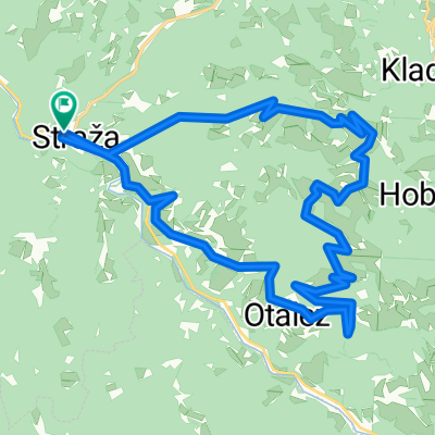
Šentviška Planota - Široko - Logaršče - Sleme
A cycling route starting in Cerkno, Cerkno, Slovenia.
Overview
About this route
The route mainly runs along paved paths, and the gradients are quite significant. Along the way, there is a beautiful view of the Krn mountain range and towards Kanin in Bovšek. The trail also passes through lovely deciduous forests where the biker can get extra oxygen for the next climb. The descent from Široko to Most na Soči is short and steep, but all the more enjoyable is the rest by the beautiful artificial lake at Most na Soči, where the Soča River usually has a particularly emerald color.
- -:--
- Duration
- 56.6 km
- Distance
- 1,656 m
- Ascent
- 1,656 m
- Descent
- ---
- Avg. speed
- ---
- Max. altitude
Route highlights
Points of interest along the route
Photo after 8.2 km
Kopališče na Slapu ob Idrijci
Photo after 20.3 km
Umetnine v Grudnici
Photo after 21.3 km
Pogled iz Grudnice v rojstni kraj Sleme
Photo after 26.1 km
Juriš na Široko - najboljše dame
Photo after 26.1 km
Pogled iz Širokega na Logaršče
Photo after 35.8 km
Photo after 37 km
Senik ob poti pred Ljubinjem
Continue with Bikemap
Use, edit, or download this cycling route
You would like to ride Šentviška Planota - Široko - Logaršče - Sleme or customize it for your own trip? Here is what you can do with this Bikemap route:
Free features
- Save this route as favorite or in collections
- Copy & plan your own version of this route
- Sync your route with Garmin or Wahoo
Premium features
Free trial for 3 days, or one-time payment. More about Bikemap Premium.
- Navigate this route on iOS & Android
- Export a GPX / KML file of this route
- Create your custom printout (try it for free)
- Download this route for offline navigation
Discover more Premium features.
Get Bikemap PremiumFrom our community
Other popular routes starting in Cerkno
- Sleme - Hudournik - Golaki
- Distance
- 91.9 km
- Ascent
- 2,076 m
- Descent
- 2,076 m
- Location
- Cerkno, Cerkno, Slovenia
- bike from Cerkno to Ski resort Cerkno
- Distance
- 26.9 km
- Ascent
- 894 m
- Descent
- 894 m
- Location
- Cerkno, Cerkno, Slovenia
- Trebuša loop
- Distance
- 33.5 km
- Ascent
- 1,086 m
- Descent
- 1,077 m
- Location
- Cerkno, Cerkno, Slovenia
- Trebuša - Čepovan MTB
- Distance
- 31.2 km
- Ascent
- 950 m
- Descent
- 949 m
- Location
- Cerkno, Cerkno, Slovenia
- Tilnik
- Distance
- 27.3 km
- Ascent
- 933 m
- Descent
- 933 m
- Location
- Cerkno, Cerkno, Slovenia
- Sleme - Baška Grapa - Blegoš - Poče - Sleme
- Distance
- 103.6 km
- Ascent
- 2,126 m
- Descent
- 2,126 m
- Location
- Cerkno, Cerkno, Slovenia
- CerknoSebrelje
- Distance
- 53.4 km
- Ascent
- 1,055 m
- Descent
- 1,054 m
- Location
- Cerkno, Cerkno, Slovenia
- Hudajužna ŽP-Cerkno
- Distance
- 18.9 km
- Ascent
- 1,095 m
- Descent
- 1,175 m
- Location
- Cerkno, Cerkno, Slovenia
Open it in the app