Grabels-Val du Hérault 93
A cycling route starting in Grabels, Occitanie, France.
Overview
About this route
A magnificent road! Very little traffic. Wonderful Hérault valley!
- -:--
- Duration
- 93.2 km
- Distance
- 1,139 m
- Ascent
- 1,140 m
- Descent
- ---
- Avg. speed
- 328 m
- Max. altitude
Route quality
Waytypes & surfaces along the route
Waytypes
Road
42.9 km
(46 %)
Track
4.7 km
(5 %)
Surfaces
Paved
56.9 km
(61 %)
Unpaved
2.8 km
(3 %)
Asphalt
56.9 km
(61 %)
Ground
1.9 km
(2 %)
Continue with Bikemap
Use, edit, or download this cycling route
You would like to ride Grabels-Val du Hérault 93 or customize it for your own trip? Here is what you can do with this Bikemap route:
Free features
- Save this route as favorite or in collections
- Copy & plan your own version of this route
- Split it into stages to create a multi-day tour
- Sync your route with Garmin or Wahoo
Premium features
Free trial for 3 days, or one-time payment. More about Bikemap Premium.
- Navigate this route on iOS & Android
- Export a GPX / KML file of this route
- Create your custom printout (try it for free)
- Download this route for offline navigation
Discover more Premium features.
Get Bikemap PremiumFrom our community
Other popular routes starting in Grabels
Grabels-Val du Hérault 93- Distance
- 93.2 km
- Ascent
- 1,139 m
- Descent
- 1,140 m
- Location
- Grabels, Occitanie, France
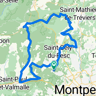
Balade au pied du Pic Saint-Loup- Distance
- 44.8 km
- Ascent
- 250 m
- Descent
- 247 m
- Location
- Grabels, Occitanie, France
Sortie Grabels Prades 70km- Distance
- 69.7 km
- Ascent
- 482 m
- Descent
- 479 m
- Location
- Grabels, Occitanie, France
Grabels-Val du Hérault 85 Route à Merveille- Distance
- 87.2 km
- Ascent
- 1,105 m
- Descent
- 1,108 m
- Location
- Grabels, Occitanie, France
A/R à Saint Gély du Fesc- Distance
- 21.3 km
- Ascent
- 245 m
- Descent
- 237 m
- Location
- Grabels, Occitanie, France
balade facile- Distance
- 47 km
- Ascent
- 439 m
- Descent
- 439 m
- Location
- Grabels, Occitanie, France
De Rue de la Valsière 554, Grabels à Rue de l'Oliveraie 30, Grabels- Distance
- 19.8 km
- Ascent
- 184 m
- Descent
- 263 m
- Location
- Grabels, Occitanie, France
Malbosc - Taillade - La Boissière- Distance
- 77.7 km
- Ascent
- 603 m
- Descent
- 603 m
- Location
- Grabels, Occitanie, France
Open it in the app


