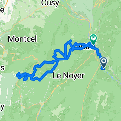
Arith Revard
A cycling route starting in Cusy, Auvergne-Rh么ne-Alpes, France.
Overview
About this route
- 3 h 17 min
- Duration
- 42.4 km
- Distance
- 1,426 m
- Ascent
- 1,454 m
- Descent
- 12.9 km/h
- Avg. speed
- 1,530 m
- Max. altitude
Route quality
Waytypes & surfaces along the route
Waytypes
Quiet road
1.7 km
(4 %)
Track
1.7 km
(4 %)
Surfaces
Paved
0.8 km
(2 %)
Unpaved
0.8 km
(2 %)
Asphalt
0.8 km
(2 %)
Gravel
0.4 km
(1 %)
Continue with Bikemap
Use, edit, or download this cycling route
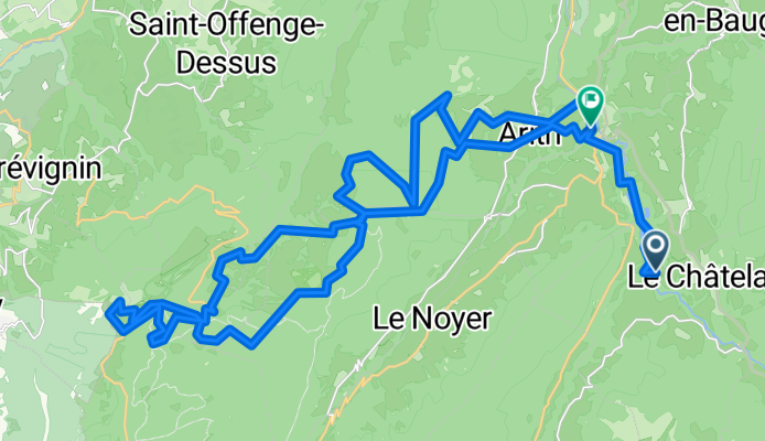
You would like to ride Arith Revard or customize it for your own trip? Here is what you can do with this Bikemap route:
Free features
- Save this route as favorite or in collections
- Copy & plan your own version of this route
- Sync your route with Garmin or Wahoo
Premium features
Free trial for 3 days, or one-time payment. More about Bikemap Premium.
- Navigate this route on iOS & Android
- Export a GPX / KML file of this route
- Create your custom printout (try it for free)
- Download this route for offline navigation
Discover more Premium features.
Get Bikemap PremiumFrom our community
Other popular routes starting in Cusy
St Ours - Hauteville Lompnes - Les Rousses - Sciez - Thorens les Gli猫res - St Ours- Distance
- 360 km
- Ascent
- 3,380 m
- Descent
- 3,381 m
- Location
- Cusy, Auvergne-Rh么ne-Alpes, France
etape 8- Distance
- 105.1 km
- Ascent
- 891 m
- Descent
- 732 m
- Location
- Cusy, Auvergne-Rh么ne-Alpes, France
Arith Revard- Distance
- 42.4 km
- Ascent
- 1,426 m
- Descent
- 1,454 m
- Location
- Cusy, Auvergne-Rh么ne-Alpes, France
Mognard - Gr茅sy - Le Montcel - St Offenge - Cusy- Distance
- 28.5 km
- Ascent
- 481 m
- Descent
- 481 m
- Location
- Cusy, Auvergne-Rh么ne-Alpes, France
Arith 1- Distance
- 100.1 km
- Ascent
- 2,024 m
- Descent
- 2,024 m
- Location
- Cusy, Auvergne-Rh么ne-Alpes, France
Col du Sapenay - Le Grand Colombier - Col de la Chambotte- Distance
- 104.3 km
- Ascent
- 2,455 m
- Descent
- 2,455 m
- Location
- Cusy, Auvergne-Rh么ne-Alpes, France
Parcour VTT au dessus de cusy- Distance
- 21.3 km
- Ascent
- 1,001 m
- Descent
- 1,001 m
- Location
- Cusy, Auvergne-Rh么ne-Alpes, France
Le Semnoz (Cr锚t de Chatillon) par Quintal- Distance
- 63.9 km
- Ascent
- 1,390 m
- Descent
- 1,390 m
- Location
- Cusy, Auvergne-Rh么ne-Alpes, France
Open it in the app

