

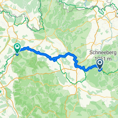
Gustav-Leutelt-Straße 20A, Fichtelberg nach Hauptstraße 80, Erlangen
A cycling route starting in Fichtelberg, Bavaria, Germany.
Overview
About this route
- 6 h 29 min
- Duration
- 101.8 km
- Distance
- 850 m
- Ascent
- 1,287 m
- Descent
- 15.7 km/h
- Avg. speed
- 745 m
- Avg. speed

Route quality
Waytypes & surfaces along the route
Waytypes
Quiet road
39.6 km
(39 %)
Path
27.8 km
(27 %)
Surfaces
Paved
78.4 km
(77 %)
Unpaved
1.7 km
(2 %)
Asphalt
71.6 km
(70 %)
Paved (undefined)
5 km
(5 %)
Continue with Bikemap
Use, edit, or download this cycling route
You would like to ride Gustav-Leutelt-Straße 20A, Fichtelberg nach Hauptstraße 80, Erlangen or customize it for your own trip? Here is what you can do with this Bikemap route:
Free features
- Save this route as favorite or in collections
- Copy & plan your own version of this route
- Split it into stages to create a multi-day tour
- Sync your route with Garmin or Wahoo
Premium features
Free trial for 3 days, or one-time payment. More about Bikemap Premium.
- Navigate this route on iOS & Android
- Export a GPX / KML file of this route
- Create your custom printout (try it for free)
- Download this route for offline navigation
Discover more Premium features.
Get Bikemap PremiumFrom our community
Other popular routes starting in Fichtelberg
 tag_01_fichtelgebirge
- Distance
- 74.5 km
- Ascent
- 689 m
- Descent
- 840 m
- Location
- Fichtelberg, Bavaria, Germany
 SeehausParkplatz-Karches-Haberstein-Schneeberg-Nusshardt-Seehaus-Fichtelsee-Wunsiedel-HStädt-Selb-SD
- Distance
- 60.3 km
- Ascent
- 671 m
- Descent
- 788 m
- Location
- Fichtelberg, Bavaria, Germany
 50.015° N 11.847° W nach Am Fichtelsee 1, Fichtelberg
- Distance
- 20.4 km
- Ascent
- 500 m
- Descent
- 522 m
- Location
- Fichtelberg, Bavaria, Germany
 mnebike2
- Distance
- 42.4 km
- Ascent
- 792 m
- Descent
- 746 m
- Location
- Fichtelberg, Bavaria, Germany
 Německo 2012-3.den- WeiserMain-Radweg
- Distance
- 91.7 km
- Ascent
- 162 m
- Descent
- 771 m
- Location
- Fichtelberg, Bavaria, Germany
 Kösseine Fichtelgebirge MTB
- Distance
- 59.2 km
- Ascent
- 1,065 m
- Descent
- 1,065 m
- Location
- Fichtelberg, Bavaria, Germany
 Schöne Ochsenkopf - SchneebergTour
- Distance
- 30.5 km
- Ascent
- 663 m
- Descent
- 663 m
- Location
- Fichtelberg, Bavaria, Germany
 Fichtelgebirge Gipfeltour
- Distance
- 25.3 km
- Ascent
- 707 m
- Descent
- 707 m
- Location
- Fichtelberg, Bavaria, Germany
Open it in the app