

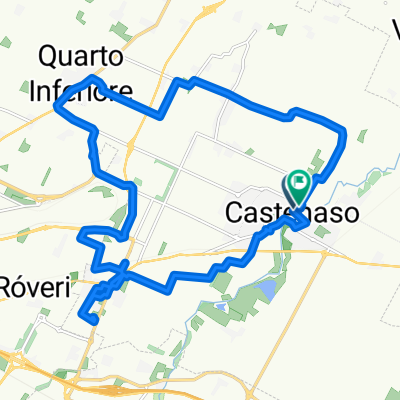
ripresa bici!
A cycling route starting in Castenaso, Emilia-Romagna, Italy.
Overview
About this route
- 1 h 48 min
- Duration
- 32.9 km
- Distance
- 55 m
- Ascent
- 101 m
- Descent
- 18.3 km/h
- Avg. speed
- 81 m
- Max. altitude

Route quality
Waytypes & surfaces along the route
Waytypes
Road
21.4 km
(65 %)
Quiet road
8.9 km
(27 %)
Surfaces
Paved
15.5 km
(47 %)
Unpaved
1.6 km
(5 %)
Asphalt
15.5 km
(47 %)
Gravel
1.3 km
(4 %)
Continue with Bikemap
Use, edit, or download this cycling route
You would like to ride ripresa bici! or customize it for your own trip? Here is what you can do with this Bikemap route:
Free features
- Save this route as favorite or in collections
- Copy & plan your own version of this route
- Sync your route with Garmin or Wahoo
Premium features
Free trial for 3 days, or one-time payment. More about Bikemap Premium.
- Navigate this route on iOS & Android
- Export a GPX / KML file of this route
- Create your custom printout (try it for free)
- Download this route for offline navigation
Discover more Premium features.
Get Bikemap PremiumFrom our community
Other popular routes starting in Castenaso
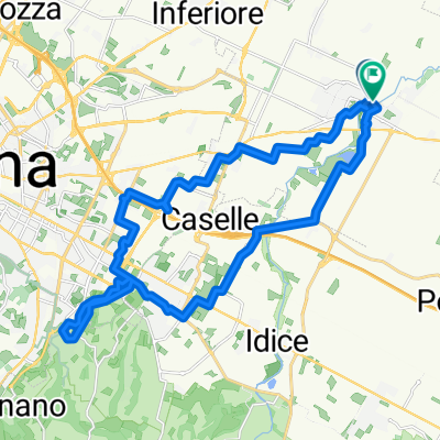
 Villanova e marano
- Distance
- 22.7 km
- Ascent
- 86 m
- Descent
- 131 m
- Location
- Castenaso, Emilia-Romagna, Italy
 Monte Calderaro/Monte Armato
- Distance
- 63.1 km
- Ascent
- 1,390 m
- Descent
- 1,380 m
- Location
- Castenaso, Emilia-Romagna, Italy
 Botteghino ripresa
- Distance
- 36.4 km
- Ascent
- 303 m
- Descent
- 339 m
- Location
- Castenaso, Emilia-Romagna, Italy
 GRANFONDO DELL'UVA PERCORSO LUNGO
- Distance
- 136.7 km
- Ascent
- 1,337 m
- Descent
- 1,336 m
- Location
- Castenaso, Emilia-Romagna, Italy
 13b Bolo-Flor östl. Nebenstrecke
- Distance
- 121.1 km
- Ascent
- 1,022 m
- Descent
- 960 m
- Location
- Castenaso, Emilia-Romagna, Italy
 Zula Zena 02giugno2021
- Distance
- 59.9 km
- Ascent
- 1,254 m
- Descent
- 1,236 m
- Location
- Castenaso, Emilia-Romagna, Italy
 Percorso a Castenaso
- Distance
- 27.7 km
- Ascent
- 119 m
- Descent
- 121 m
- Location
- Castenaso, Emilia-Romagna, Italy
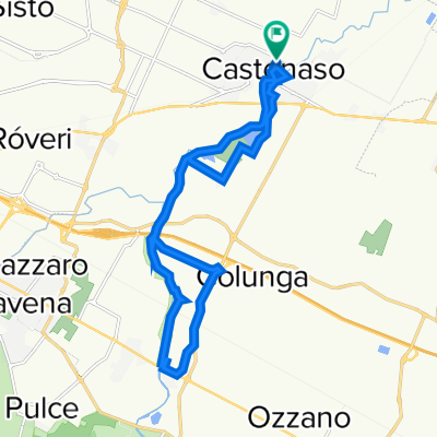 lungo Idice Idice colunga golf
- Distance
- 18.9 km
- Ascent
- 91 m
- Descent
- 99 m
- Location
- Castenaso, Emilia-Romagna, Italy
Open it in the app