

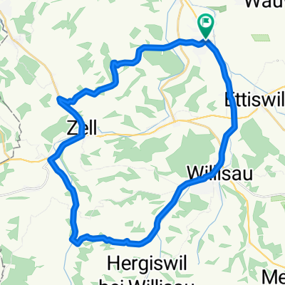
Schötz-Sursee
A cycling route starting in Schötz, Canton of Lucerne, Switzerland.
Overview
About this route
- 1 h 2 min
- Duration
- 16.7 km
- Distance
- 177 m
- Ascent
- 236 m
- Descent
- 16.1 km/h
- Avg. speed
- 634 m
- Max. altitude

Route quality
Waytypes & surfaces along the route
Waytypes
Track
8.3 km
(50 %)
Quiet road
5.5 km
(33 %)
Surfaces
Paved
5.5 km
(33 %)
Unpaved
7 km
(42 %)
Gravel
5.3 km
(32 %)
Asphalt
3.8 km
(23 %)
Continue with Bikemap
Use, edit, or download this cycling route
You would like to ride Schötz-Sursee or customize it for your own trip? Here is what you can do with this Bikemap route:
Free features
- Save this route as favorite or in collections
- Copy & plan your own version of this route
- Sync your route with Garmin or Wahoo
Premium features
Free trial for 3 days, or one-time payment. More about Bikemap Premium.
- Navigate this route on iOS & Android
- Export a GPX / KML file of this route
- Create your custom printout (try it for free)
- Download this route for offline navigation
Discover more Premium features.
Get Bikemap PremiumFrom our community
Other popular routes starting in Schötz
 Fadenwegring 17, Schötz nach Ausserdorfstrasse 28, Schötz
- Distance
- 38.8 km
- Ascent
- 312 m
- Descent
- 310 m
- Location
- Schötz, Canton of Lucerne, Switzerland
 Ober-Neubühl 1, Schötz to Ober-Neubühl 1, Schötz
- Distance
- 20.9 km
- Ascent
- 118 m
- Descent
- 115 m
- Location
- Schötz, Canton of Lucerne, Switzerland
 Langsame Fahrt in Schötz
- Distance
- 35.4 km
- Ascent
- 420 m
- Descent
- 362 m
- Location
- Schötz, Canton of Lucerne, Switzerland
 Schötz-Sursee
- Distance
- 16.7 km
- Ascent
- 177 m
- Descent
- 236 m
- Location
- Schötz, Canton of Lucerne, Switzerland
 Zum Napf
- Distance
- 28.8 km
- Ascent
- 416 m
- Descent
- 418 m
- Location
- Schötz, Canton of Lucerne, Switzerland
 Gemütliche Route in Schötz
- Distance
- 12 km
- Ascent
- 64 m
- Descent
- 61 m
- Location
- Schötz, Canton of Lucerne, Switzerland
 Nebikerstrasse 18, Schötz nach Haldenmattstrasse 14, Sursee
- Distance
- 10.8 km
- Ascent
- 24 m
- Descent
- 29 m
- Location
- Schötz, Canton of Lucerne, Switzerland
 Heidi
Heidi- Distance
- 58.3 km
- Ascent
- 148 m
- Descent
- 148 m
- Location
- Schötz, Canton of Lucerne, Switzerland
Open it in the app