

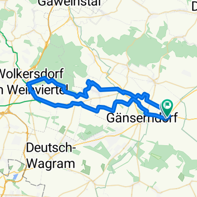
Ollersdorf-Ebenthal-Ollersdorf-Angern-Wkdf.
A cycling route starting in Weikendorf, Lower Austria, Austria.
Overview
About this route
- 5 h 41 min
- Duration
- 41.7 km
- Distance
- 452 m
- Ascent
- 453 m
- Descent
- 7.3 km/h
- Avg. speed
- 268 m
- Max. altitude

Route quality
Waytypes & surfaces along the route
Waytypes
Track
13.3 km
(32 %)
Quiet road
10.4 km
(25 %)
Surfaces
Paved
28.4 km
(68 %)
Unpaved
8.8 km
(21 %)
Asphalt
26.3 km
(63 %)
Gravel
4.6 km
(11 %)
Continue with Bikemap
Use, edit, or download this cycling route
You would like to ride Ollersdorf-Ebenthal-Ollersdorf-Angern-Wkdf. or customize it for your own trip? Here is what you can do with this Bikemap route:
Free features
- Save this route as favorite or in collections
- Copy & plan your own version of this route
- Sync your route with Garmin or Wahoo
Premium features
Free trial for 3 days, or one-time payment. More about Bikemap Premium.
- Navigate this route on iOS & Android
- Export a GPX / KML file of this route
- Create your custom printout (try it for free)
- Download this route for offline navigation
Discover more Premium features.
Get Bikemap PremiumFrom our community
Other popular routes starting in Weikendorf
 Ollersdorf-Ebenthal-Ollersdorf-Angern-Wkdf.
- Distance
- 41.7 km
- Ascent
- 452 m
- Descent
- 453 m
- Location
- Weikendorf, Lower Austria, Austria
 3. den rozšíření
- Distance
- 68.6 km
- Ascent
- 181 m
- Descent
- 172 m
- Location
- Weikendorf, Lower Austria, Austria
 Wkdf.- Oll-Ebenthal-VG-Spanberg-Dürnkrut-Ang-Wkdf.
- Distance
- 58.3 km
- Ascent
- 448 m
- Descent
- 450 m
- Location
- Weikendorf, Lower Austria, Austria
 Prottes (RC Schnecke)
- Distance
- 19 km
- Ascent
- 129 m
- Descent
- 129 m
- Location
- Weikendorf, Lower Austria, Austria
 March-Thaya (AT-SK-CZ)
- Distance
- 404.9 km
- Ascent
- 821 m
- Descent
- 824 m
- Location
- Weikendorf, Lower Austria, Austria
 Wkdf. -Pillichsdorf- Wolkersdorf-Zweigelt Radweg- Reyersdorf- Wkdf.
- Distance
- 52.2 km
- Ascent
- 192 m
- Descent
- 192 m
- Location
- Weikendorf, Lower Austria, Austria
 Wkdf. über Stempflbachweg n. Groissenbrunn - Schloßhof- Marchegg-Wkdf.
- Distance
- 61.5 km
- Ascent
- 107 m
- Descent
- 104 m
- Location
- Weikendorf, Lower Austria, Austria
 Runde 1
- Distance
- 57.8 km
- Ascent
- 44 m
- Descent
- 42 m
- Location
- Weikendorf, Lower Austria, Austria
Open it in the app