

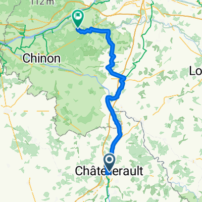
SityTrail - 001C Chatellerault St Jacques to St Savin via Angles and En Lo
A cycling route starting in Châtellerault, Nouvelle-Aquitaine, France.
Overview
About this route
A reasonable route that uses minor roads. Has accomodation at En Lo, Le Bas Premilly but avoids Paizay. Accomodation and campsite in Chatellerault, Campsite St Pierre de Maillé and St Savin. The detour via the railway line after En Lo could be omitted but it's the most pleasant route. It really isn't necessary to go via Angles sur l'Anglin unless you want to visit the castle ruins, just follow the signs from Pleumartin to St Pierre de Maillé. - A reasonable route that uses minor roads. Has accomodation at En Lo, Le Bas Premilly but avoids Paizay. Accomodation and campsite in Chatellerault, Campsite St Pierre de Maillé and St Savin. The detour via the railway line after En Lo could be omitted but it's the most pleasant route. It really isn't necessary to go via Angles sur l'Anglin unless you want to visit the castle ruins, just follow the signs from Pleumartin to St Pierre de Maillé.
- -:--
- Duration
- 61.2 km
- Distance
- 490 m
- Ascent
- 462 m
- Descent
- ---
- Avg. speed
- 144 m
- Max. altitude

Route quality
Waytypes & surfaces along the route
Waytypes
Quiet road
26.8 km
(44 %)
Busy road
15.3 km
(25 %)
Surfaces
Paved
6.7 km
(11 %)
Unpaved
5.4 km
(9 %)
Asphalt
6.7 km
(11 %)
Gravel
5.4 km
(9 %)
Undefined
49 km
(80 %)
Continue with Bikemap
Use, edit, or download this cycling route
You would like to ride SityTrail - 001C Chatellerault St Jacques to St Savin via Angles and En Lo or customize it for your own trip? Here is what you can do with this Bikemap route:
Free features
- Save this route as favorite or in collections
- Copy & plan your own version of this route
- Sync your route with Garmin or Wahoo
Premium features
Free trial for 3 days, or one-time payment. More about Bikemap Premium.
- Navigate this route on iOS & Android
- Export a GPX / KML file of this route
- Create your custom printout (try it for free)
- Download this route for offline navigation
Discover more Premium features.
Get Bikemap PremiumFrom our community
Other popular routes starting in Châtellerault
 (4) Final Chattelerault - Bordeaux, 282km, 990HM (camping)
- Distance
- 282.2 km
- Ascent
- 574 m
- Descent
- 592 m
- Location
- Châtellerault, Nouvelle-Aquitaine, France
 4 Chatellerault - Onder Bordeaux (Camping), 282 km
- Distance
- 282.4 km
- Ascent
- 569 m
- Descent
- 587 m
- Location
- Châtellerault, Nouvelle-Aquitaine, France
 FR15 Chatelleraut - Cheillé
- Distance
- 78.3 km
- Ascent
- 460 m
- Descent
- 461 m
- Location
- Châtellerault, Nouvelle-Aquitaine, France
 France20.5 Chatellerault-Confolens
- Distance
- 109 km
- Ascent
- 356 m
- Descent
- 281 m
- Location
- Châtellerault, Nouvelle-Aquitaine, France
 DAY ONE Châtellerault - Savigny-sous-Faye
- Distance
- 24.5 km
- Ascent
- 138 m
- Descent
- 79 m
- Location
- Châtellerault, Nouvelle-Aquitaine, France
 SityTrail - 001C Chatellerault St Jacques to St Savin via Angles and En Lo
- Distance
- 61.2 km
- Ascent
- 490 m
- Descent
- 462 m
- Location
- Châtellerault, Nouvelle-Aquitaine, France
 dangé velleches usseau
- Distance
- 39.7 km
- Ascent
- 374 m
- Descent
- 374 m
- Location
- Châtellerault, Nouvelle-Aquitaine, France
 Chatellerault - Lussac Les Châteaux (60 km) - Chabanais (71 km)
- Distance
- 131 km
- Ascent
- 1,044 m
- Descent
- 939 m
- Location
- Châtellerault, Nouvelle-Aquitaine, France
Open it in the app