Overview
About this route
- -:--
- Duration
- 45.9 km
- Distance
- 769 m
- Ascent
- 808 m
- Descent
- ---
- Avg. speed
- 358 m
- Max. altitude
Part of
Apennin Querung
6 stages
Route quality
Waytypes & surfaces along the route
Waytypes
Road
13.3 km
(29 %)
Quiet road
12.9 km
(28 %)
Surfaces
Paved
25.3 km
(55 %)
Asphalt
25.3 km
(55 %)
Undefined
20.7 km
(45 %)
Continue with Bikemap
Use, edit, or download this cycling route
You would like to ride Q6 Vinci - Montecatini Terme or customize it for your own trip? Here is what you can do with this Bikemap route:
Free features
- Save this route as favorite or in collections
- Copy & plan your own version of this route
- Sync your route with Garmin or Wahoo
Premium features
Free trial for 3 days, or one-time payment. More about Bikemap Premium.
- Navigate this route on iOS & Android
- Export a GPX / KML file of this route
- Create your custom printout (try it for free)
- Download this route for offline navigation
Discover more Premium features.
Get Bikemap PremiumFrom our community
Other popular routes starting in Vinci
Route from Vinci- Distance
- 4.5 km
- Ascent
- 80 m
- Descent
- 86 m
- Location
- Vinci, Tuscany, Italy
Giro d'Italia 2019 - Stage 3- Distance
- 219 km
- Ascent
- 1,140 m
- Descent
- 1,170 m
- Location
- Vinci, Tuscany, Italy
From Vinci to Lamporecchio- Distance
- 50.9 km
- Ascent
- 1,714 m
- Descent
- 1,729 m
- Location
- Vinci, Tuscany, Italy
Q6 Vinci - Montecatini Terme- Distance
- 45.9 km
- Ascent
- 769 m
- Descent
- 808 m
- Location
- Vinci, Tuscany, Italy
From Vinci to Signa- Distance
- 57.3 km
- Ascent
- 1,185 m
- Descent
- 1,186 m
- Location
- Vinci, Tuscany, Italy
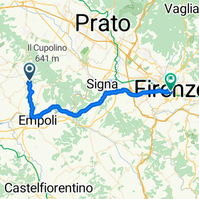
MONTALBANO 1 (S. AMATO)- Distance
- 12 km
- Ascent
- 593 m
- Descent
- 595 m
- Location
- Vinci, Tuscany, Italy
Vinci Prato Pistoia- Distance
- 60.5 km
- Ascent
- 600 m
- Descent
- 601 m
- Location
- Vinci, Tuscany, Italy
Pietramarina- Distance
- 38.7 km
- Ascent
- 870 m
- Descent
- 870 m
- Location
- Vinci, Tuscany, Italy
Open it in the app


