

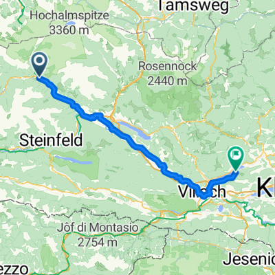
Mallnitz - Tarvis
A cycling route starting in Obervellach, Carinthia, Austria.
Overview
About this route
- -:--
- Duration
- 116 km
- Distance
- 963 m
- Ascent
- 1,390 m
- Descent
- ---
- Avg. speed
- 1,185 m
- Max. altitude
Route quality
Waytypes & surfaces along the route
Waytypes
Cycleway
53.3 km
(46 %)
Quiet road
26.7 km
(23 %)
Surfaces
Paved
63.8 km
(55 %)
Unpaved
24.3 km
(21 %)
Asphalt
55.7 km
(48 %)
Loose gravel
16.2 km
(14 %)
Continue with Bikemap
Use, edit, or download this cycling route
You would like to ride Mallnitz - Tarvis or customize it for your own trip? Here is what you can do with this Bikemap route:
Free features
- Save this route as favorite or in collections
- Copy & plan your own version of this route
- Split it into stages to create a multi-day tour
- Sync your route with Garmin or Wahoo
Premium features
Free trial for 3 days, or one-time payment. More about Bikemap Premium.
- Navigate this route on iOS & Android
- Export a GPX / KML file of this route
- Create your custom printout (try it for free)
- Download this route for offline navigation
Discover more Premium features.
Get Bikemap PremiumFrom our community
Other popular routes starting in Obervellach
 Steindorf am Ossiacher See - Pontebba (1/2)
- Distance
- 90 km
- Ascent
- 877 m
- Descent
- 1,042 m
- Location
- Obervellach, Carinthia, Austria
 Alpe-Adria Oberfellach - Bischofshofen
- Distance
- 79.5 km
- Ascent
- 3,557 m
- Descent
- 3,695 m
- Location
- Obervellach, Carinthia, Austria
 RCO 2018 Grado 1. Tag 2. Etappe
- Distance
- 7.6 km
- Ascent
- 33 m
- Descent
- 503 m
- Location
- Obervellach, Carinthia, Austria
 9_del2_Mallnitz - Grado
- Distance
- 262.7 km
- Ascent
- 393 m
- Descent
- 1,610 m
- Location
- Obervellach, Carinthia, Austria
 Etapa 056B-2 (Salzburgo - Sachsenburg)
- Distance
- 33 km
- Ascent
- 399 m
- Descent
- 1,020 m
- Location
- Obervellach, Carinthia, Austria
 2. day around Villach 3.0
- Distance
- 79.1 km
- Ascent
- 1,582 m
- Descent
- 2,212 m
- Location
- Obervellach, Carinthia, Austria
 2. day around Villach
- Distance
- 81.5 km
- Ascent
- 756 m
- Descent
- 1,422 m
- Location
- Obervellach, Carinthia, Austria
 Alpenüberquerung Slowenien 2022 - Tag 2 (nach Tauernschleuse)
- Distance
- 21.4 km
- Ascent
- 222 m
- Descent
- 793 m
- Location
- Obervellach, Carinthia, Austria
Open it in the app