
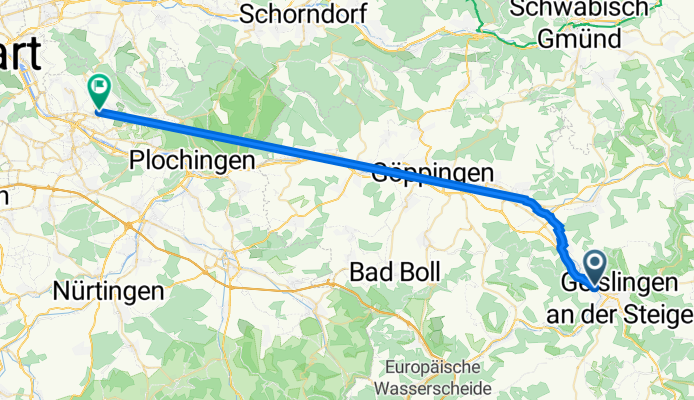
Stuttgarter Straße 350, Geislingen an der Steige nach Goerdelerweg 88, Esslingen am Neckar
A cycling route starting in Kuchen, Baden-Württemberg, Germany.
Overview
About this route
- 7 h 11 min
- Duration
- 40.9 km
- Distance
- 58 m
- Ascent
- 234 m
- Descent
- 5.7 km/h
- Avg. speed
- 460 m
- Avg. speed

Route quality
Waytypes & surfaces along the route
Waytypes
Quiet road
36.1 km
(88 %)
Path
2.4 km
(6 %)
Surfaces
Paved
39 km
(95 %)
Unpaved
0.1 km
(<1 %)
Asphalt
38.4 km
(94 %)
Paved (undefined)
0.5 km
(1 %)
Continue with Bikemap
Use, edit, or download this cycling route
You would like to ride Stuttgarter Straße 350, Geislingen an der Steige nach Goerdelerweg 88, Esslingen am Neckar or customize it for your own trip? Here is what you can do with this Bikemap route:
Free features
- Save this route as favorite or in collections
- Copy & plan your own version of this route
- Sync your route with Garmin or Wahoo
Premium features
Free trial for 3 days, or one-time payment. More about Bikemap Premium.
- Navigate this route on iOS & Android
- Export a GPX / KML file of this route
- Create your custom printout (try it for free)
- Download this route for offline navigation
Discover more Premium features.
Get Bikemap PremiumFrom our community
Other popular routes starting in Kuchen
 Kuchen Oberböhringen Scharfenberg
- Distance
- 12.8 km
- Ascent
- 348 m
- Descent
- 232 m
- Location
- Kuchen, Baden-Württemberg, Germany
 Kuchen - Süßen - Schlater Wald
- Distance
- 21.4 km
- Ascent
- 204 m
- Descent
- 204 m
- Location
- Kuchen, Baden-Württemberg, Germany
 Lange Radrunde vom 30. Juli, 10:07
- Distance
- 61.9 km
- Ascent
- 1,236 m
- Descent
- 1,236 m
- Location
- Kuchen, Baden-Württemberg, Germany
 Kuchen - Oberstaufen
- Distance
- 163.5 km
- Ascent
- 829 m
- Descent
- 469 m
- Location
- Kuchen, Baden-Württemberg, Germany
 Lange Radrunde durch Bad Überkingen
- Distance
- 48.2 km
- Ascent
- 1,395 m
- Descent
- 1,318 m
- Location
- Kuchen, Baden-Württemberg, Germany
 Trail Tour Spitzenberg - Kuchalb
- Distance
- 28.8 km
- Ascent
- 748 m
- Descent
- 748 m
- Location
- Kuchen, Baden-Württemberg, Germany
 Radltour mit Kinderspielplatz in Weiler
- Distance
- 15.5 km
- Ascent
- 428 m
- Descent
- 305 m
- Location
- Kuchen, Baden-Württemberg, Germany
 Jungfraufels Downhill - Kuchen CLONED FROM ROUTE 10079
- Distance
- 18.3 km
- Ascent
- 500 m
- Descent
- 498 m
- Location
- Kuchen, Baden-Württemberg, Germany
Open it in the app