

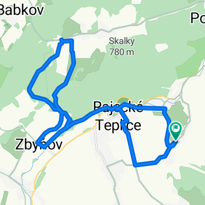
Zbyňov - Kňazova Lehota - Lietavská Svinná
A cycling route starting in Rajec, Žilina Region, Slovakia.
Overview
About this route
The more information you write here, the more useful it will be for other users.
- Route progress.
- What is special about this route?
- Why recommend this route?
- What did you like the most here?
- Etc.
- -:--
- Duration
- 17.3 km
- Distance
- 298 m
- Ascent
- 296 m
- Descent
- ---
- Avg. speed
- ---
- Max. altitude
Continue with Bikemap
Use, edit, or download this cycling route
You would like to ride Zbyňov - Kňazova Lehota - Lietavská Svinná or customize it for your own trip? Here is what you can do with this Bikemap route:
Free features
- Save this route as favorite or in collections
- Copy & plan your own version of this route
- Sync your route with Garmin or Wahoo
Premium features
Free trial for 3 days, or one-time payment. More about Bikemap Premium.
- Navigate this route on iOS & Android
- Export a GPX / KML file of this route
- Create your custom printout (try it for free)
- Download this route for offline navigation
Discover more Premium features.
Get Bikemap PremiumFrom our community
Other popular routes starting in Rajec
 Klak Cyklotrasa
- Distance
- 15.6 km
- Ascent
- 688 m
- Descent
- 717 m
- Location
- Rajec, Žilina Region, Slovakia
 2010-07-21
- Distance
- 21.3 km
- Ascent
- 667 m
- Descent
- 667 m
- Location
- Rajec, Žilina Region, Slovakia
 Zbyňov - Kňazova Lehota - Lietavská Svinná
- Distance
- 17.3 km
- Ascent
- 298 m
- Descent
- 296 m
- Location
- Rajec, Žilina Region, Slovakia
 Stranske - Lietavska Svinna
- Distance
- 20.7 km
- Ascent
- 526 m
- Descent
- 524 m
- Location
- Rajec, Žilina Region, Slovakia
 Stránske do Stránske
- Distance
- 27.8 km
- Ascent
- 375 m
- Descent
- 422 m
- Location
- Rajec, Žilina Region, Slovakia
 11.4.2018 LS - Sulov OKRUH
- Distance
- 24 km
- Ascent
- 685 m
- Descent
- 685 m
- Location
- Rajec, Žilina Region, Slovakia
 2010-07-14 Lietava
- Distance
- 20.7 km
- Ascent
- 341 m
- Descent
- 336 m
- Location
- Rajec, Žilina Region, Slovakia
 Stránske do Stránske
- Distance
- 38.6 km
- Ascent
- 444 m
- Descent
- 481 m
- Location
- Rajec, Žilina Region, Slovakia
Open it in the app