
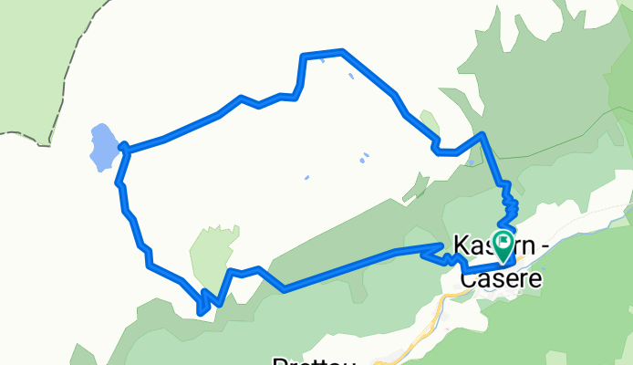
Anello: Casere - Waldnersee
A cycling route starting in Prettau, Trentino-Alto Adige, Italy.
Overview
About this route
Clockwise. Waldner Alm +2h
On the return, a shorter variant towards Casere (if by bus).
- 1 h 10 min
- Duration
- 11.6 km
- Distance
- 909 m
- Ascent
- 906 m
- Descent
- 9.9 km/h
- Avg. speed
- 2,397 m
- Max. altitude
Route highlights
Points of interest along the route
Point of interest after 2.2 km
Waldner Alm (2h da Predoi)
Point of interest after 6.7 km
Biotopo
Continue with Bikemap
Use, edit, or download this cycling route
You would like to ride Anello: Casere - Waldnersee or customize it for your own trip? Here is what you can do with this Bikemap route:
Free features
- Save this route as favorite or in collections
- Copy & plan your own version of this route
- Sync your route with Garmin or Wahoo
Premium features
Free trial for 3 days, or one-time payment. More about Bikemap Premium.
- Navigate this route on iOS & Android
- Export a GPX / KML file of this route
- Create your custom printout (try it for free)
- Download this route for offline navigation
Discover more Premium features.
Get Bikemap PremiumFrom our community
Other popular routes starting in Prettau
 Casere - Rif.Tridentina - Rif.Vetta d'Italia
- Distance
- 19.9 km
- Ascent
- 1,123 m
- Descent
- 1,124 m
- Location
- Prettau, Trentino-Alto Adige, Italy
 S. Pietro - Molini di Tures
- Distance
- 23.3 km
- Ascent
- 292 m
- Descent
- 683 m
- Location
- Prettau, Trentino-Alto Adige, Italy
 Malga Alprechalm
- Distance
- 5.2 km
- Ascent
- 569 m
- Descent
- 20 m
- Location
- Prettau, Trentino-Alto Adige, Italy
 Casere - TauernAlm - Rif.Vetta d'Italia
- Distance
- 15.3 km
- Ascent
- 968 m
- Descent
- 966 m
- Location
- Prettau, Trentino-Alto Adige, Italy
 Casere - Rifugio Tridentina - Vetta D'Italia
- Distance
- 20 km
- Ascent
- 1,112 m
- Descent
- 1,107 m
- Location
- Prettau, Trentino-Alto Adige, Italy
 Prettau -Plätzwiese
- Distance
- 86.5 km
- Ascent
- 2,397 m
- Descent
- 1,862 m
- Location
- Prettau, Trentino-Alto Adige, Italy
 Anello: Predoi - FuchsAlm - TauernAlm - Casere
- Distance
- 15.2 km
- Ascent
- 749 m
- Descent
- 880 m
- Location
- Prettau, Trentino-Alto Adige, Italy
 Escursione invernale a Steger Alm
- Distance
- 4.2 km
- Ascent
- 507 m
- Descent
- 0 m
- Location
- Prettau, Trentino-Alto Adige, Italy
Open it in the app