
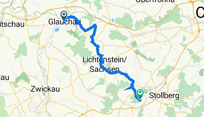
Lindenstraße 19–24, Glauchau nach Oelsnitzer Straße, Oelsnitz/Erzgebirge
A cycling route starting in Glauchau, Saxony, Germany.
Overview
About this route
- 2 h 9 min
- Duration
- 27.6 km
- Distance
- 416 m
- Ascent
- 220 m
- Descent
- 12.8 km/h
- Avg. speed
- 443 m
- Avg. speed
Route quality
Waytypes & surfaces along the route
Waytypes
Quiet road
10.4 km
(38 %)
Road
6.7 km
(24 %)
Surfaces
Paved
23.2 km
(84 %)
Unpaved
1.1 km
(4 %)
Asphalt
23 km
(83 %)
Gravel
1 km
(4 %)
Continue with Bikemap
Use, edit, or download this cycling route
You would like to ride Lindenstraße 19–24, Glauchau nach Oelsnitzer Straße, Oelsnitz/Erzgebirge or customize it for your own trip? Here is what you can do with this Bikemap route:
Free features
- Save this route as favorite or in collections
- Copy & plan your own version of this route
- Sync your route with Garmin or Wahoo
Premium features
Free trial for 3 days, or one-time payment. More about Bikemap Premium.
- Navigate this route on iOS & Android
- Export a GPX / KML file of this route
- Create your custom printout (try it for free)
- Download this route for offline navigation
Discover more Premium features.
Get Bikemap PremiumFrom our community
Other popular routes starting in Glauchau
 RBT Glauchau - Gera
- Distance
- 46.6 km
- Ascent
- 248 m
- Descent
- 294 m
- Location
- Glauchau, Saxony, Germany
 Brücke-bis-Karlsweg
- Distance
- 3.4 km
- Ascent
- 6 m
- Descent
- 9 m
- Location
- Glauchau, Saxony, Germany
 Durch Rümpfwald und Mülsengrund
- Distance
- 23 km
- Ascent
- 168 m
- Descent
- 157 m
- Location
- Glauchau, Saxony, Germany
 Team Steile Wand Fichtelbergtour 2014
- Distance
- 176.1 km
- Ascent
- 1,581 m
- Descent
- 1,584 m
- Location
- Glauchau, Saxony, Germany
 BA-GL3 15 km üb Lobsd B180 Hohenst-Ernstt
- Distance
- 15 km
- Ascent
- 212 m
- Descent
- 146 m
- Location
- Glauchau, Saxony, Germany
 Radtour kindgerecht ab 4 Jahre
- Distance
- 17.8 km
- Ascent
- 67 m
- Descent
- 34 m
- Location
- Glauchau, Saxony, Germany
 Fichtelbergtour 2013
- Distance
- 185.4 km
- Ascent
- 1,731 m
- Descent
- 1,730 m
- Location
- Glauchau, Saxony, Germany
 Fichtelbergrunde
- Distance
- 146.3 km
- Ascent
- 1,770 m
- Descent
- 1,673 m
- Location
- Glauchau, Saxony, Germany
Open it in the app